You are here: Home > Network List > AU - Australian Seismological Centre Stations List
> Station FORT Forrest, Western Australia > Earthquake Result Viewer
FORT Forrest, Western Australia - Earthquake Result Viewer
| Earthquake location: |
Fiji Islands Region |
| Earthquake latitude/longitude: |
-21.6/-179.5 |
| Earthquake time(UTC): |
2011/09/15 (258) 19:31:04 GMT |
| Earthquake Depth: |
645 km |
| Earthquake Magnitude: |
6.1 MB, 7.3 MW, 7.3 MW |
| Earthquake Catalog/Contributor: |
WHDF/NEIC |
|
| Network: |
AU Australian Seismological Centre |
| Station: |
FORT Forrest, Western Australia |
| Lat/Lon: |
30.78 S/128.06 E |
| Elevation: |
165 m |
|
| Distance: |
47.5 deg |
| Az: |
247.564 deg |
| Baz: |
92.029 deg |
| Ray Param: |
0.06672292 |
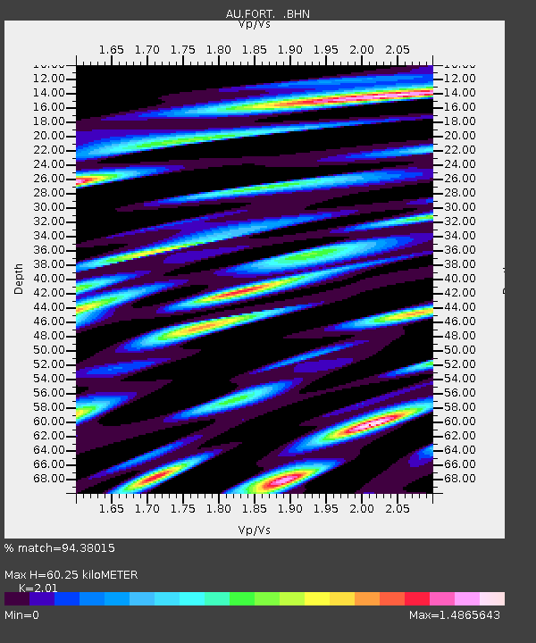
| Estimated Moho Depth: |
60.25 km |
| Estimated Crust Vp/Vs: |
2.01 |
| Assumed Crust Vp: |
6.479 km/s |
| Estimated Crust Vs: |
3.224 km/s |
| Estimated Crust Poisson's Ratio: |
0.34 |
|
| Radial Match: |
94.38015 % |
| Radial Bump: |
400 |
| Transverse Match: |
84.94187 % |
| Transverse Bump: |
400 |
| SOD ConfigId: |
414626 |
| Insert Time: |
2012-01-23 12:50:14.816 +0000 |
| GWidth: |
2.5 |
| Max Bumps: |
400 |
| Tol: |
0.001 |
|

Signal To Noise
| Channel | StoN | STA | LTA |
| AU:FORT: :BHZ:20110915T19:38:13.095015Z | 30.687637 | 1.5046177E-4 | 4.903009E-6 |
| AU:FORT: :BHN:20110915T19:38:13.095015Z | 7.4380064 | 2.2650443E-5 | 3.0452304E-6 |
| AU:FORT: :BHE:20110915T19:38:13.095015Z | 39.374508 | 1.1827375E-4 | 3.003815E-6 |
| Arrivals |
| Ps | 9.9 SECOND |
| PpPs | 27 SECOND |
| PsPs/PpSs | 37 SECOND |


