You are here: Home > Network List > AU - Australian Seismological Centre Stations List
> Station MANU Manus Island, Papau New Guinea > Earthquake Result Viewer
MANU Manus Island, Papau New Guinea - Earthquake Result Viewer
| Earthquake location: |
Fiji Islands Region |
| Earthquake latitude/longitude: |
-21.6/-179.5 |
| Earthquake time(UTC): |
2011/09/15 (258) 19:31:04 GMT |
| Earthquake Depth: |
645 km |
| Earthquake Magnitude: |
6.1 MB, 7.3 MW, 7.3 MW |
| Earthquake Catalog/Contributor: |
WHDF/NEIC |
|
| Network: |
AU Australian Seismological Centre |
| Station: |
MANU Manus Island, Papau New Guinea |
| Lat/Lon: |
2.04 S/147.37 E |
| Elevation: |
142 m |
|
| Distance: |
37.6 deg |
| Az: |
296.62 deg |
| Baz: |
123.651 deg |
| Ray Param: |
0.07255401 |
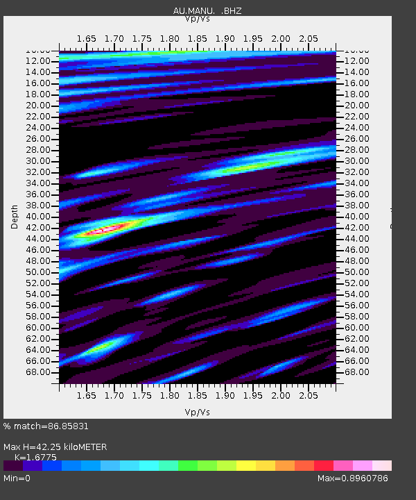
| Estimated Moho Depth: |
42.25 km |
| Estimated Crust Vp/Vs: |
1.68 |
| Assumed Crust Vp: |
4.082 km/s |
| Estimated Crust Vs: |
2.434 km/s |
| Estimated Crust Poisson's Ratio: |
0.22 |
|
| Radial Match: |
86.85831 % |
| Radial Bump: |
400 |
| Transverse Match: |
79.75346 % |
| Transverse Bump: |
400 |
| SOD ConfigId: |
414626 |
| Insert Time: |
2012-01-23 12:51:52.500 +0000 |
| GWidth: |
2.5 |
| Max Bumps: |
400 |
| Tol: |
0.001 |
|

Signal To Noise
| Channel | StoN | STA | LTA |
| AU:MANU: :BHZ:20110915T19:36:56.44499Z | 37.897068 | 2.0014757E-5 | 5.281347E-7 |
| AU:MANU: :BHN:20110915T19:36:56.44499Z | 15.2306595 | 6.602691E-6 | 4.3351312E-7 |
| AU:MANU: :BHE:20110915T19:36:56.44499Z | 22.861677 | 9.235453E-6 | 4.0397094E-7 |
| Arrivals |
| Ps | 7.2 SECOND |
| PpPs | 27 SECOND |
| PsPs/PpSs | 34 SECOND |


