You are here: Home > Network List > CI - Caltech Regional Seismic Network Stations List
> Station SWS Sam W. Stewart, Westmorland, CA, USA > Earthquake Result Viewer
SWS Sam W. Stewart, Westmorland, CA, USA - Earthquake Result Viewer

| Earthquake location: |
Fiji Islands Region |
| Earthquake latitude/longitude: |
-21.6/-179.5 |
| Earthquake time(UTC): |
2011/09/15 (258) 19:31:04 GMT |
| Earthquake Depth: |
645 km |
| Earthquake Magnitude: |
6.1 MB, 7.3 MW, 7.3 MW |
| Earthquake Catalog/Contributor: |
WHDF/NEIC |
|
| Network: |
CI Caltech Regional Seismic Network |
| Station: |
SWS Sam W. Stewart, Westmorland, CA, USA |
| Lat/Lon: |
32.94 N/115.80 W |
| Elevation: |
140 m |
|
| Distance: |
81.5 deg |
| Az: |
49.683 deg |
| Baz: |
237.54 deg |
| Ray Param: |
0.04555325 |
| Estimated Moho Depth: |
67.25 km |
| Estimated Crust Vp/Vs: |
1.62 |
| Assumed Crust Vp: |
6.155 km/s |
| Estimated Crust Vs: |
3.805 km/s |
| Estimated Crust Poisson's Ratio: |
0.19 |
|
| Radial Match: |
92.254105 % |
| Radial Bump: |
400 |
| Transverse Match: |
85.896675 % |
| Transverse Bump: |
400 |
| SOD ConfigId: |
414626 |
| Insert Time: |
2012-01-23 12:57:20.531 +0000 |
| GWidth: |
2.5 |
| Max Bumps: |
400 |
| Tol: |
0.001 |
|
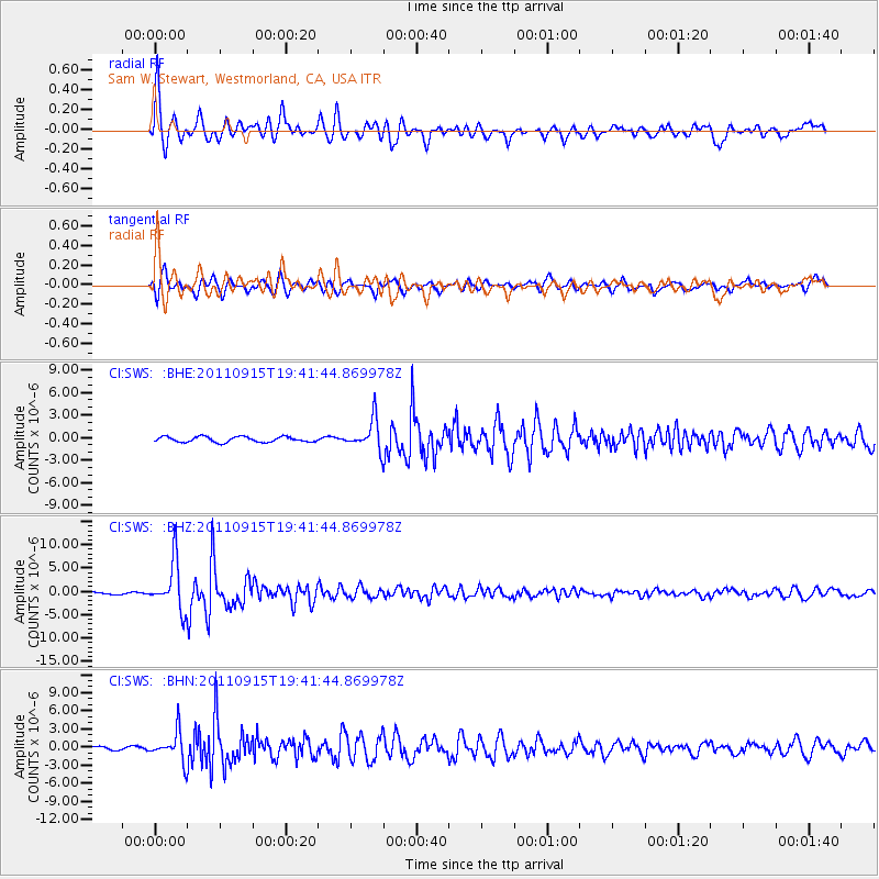
Signal To Noise
| Channel | StoN | STA | LTA |
| CI:SWS: :BHZ:20110915T19:41:44.869978Z | 20.030823 | 5.1614797E-6 | 2.5767687E-7 |
| CI:SWS: :BHN:20110915T19:41:44.869978Z | 7.611865 | 2.4099777E-6 | 3.1660804E-7 |
| CI:SWS: :BHE:20110915T19:41:44.869978Z | 5.5652375 | 2.022223E-6 | 3.633669E-7 |
| Arrivals |
| Ps | 6.9 SECOND |
| PpPs | 28 SECOND |
| PsPs/PpSs | 35 SECOND |


