You are here: Home > Network List > CI - Caltech Regional Seismic Network Stations List
> Station RCT Rector, Visalia, CA, USA > Earthquake Result Viewer
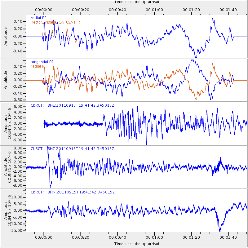
RCT Rector, Visalia, CA, USA - Earthquake Result Viewer
*The percent match for this event was below the threshold and hence no stack was calculated.
| Earthquake location: |
Fiji Islands Region |
| Earthquake latitude/longitude: |
-21.6/-179.5 |
| Earthquake time(UTC): |
2011/09/15 (258) 19:31:04 GMT |
| Earthquake Depth: |
645 km |
| Earthquake Magnitude: |
6.1 MB, 7.3 MW, 7.3 MW |
| Earthquake Catalog/Contributor: |
WHDF/NEIC |
|
| Network: |
CI Caltech Regional Seismic Network |
| Station: |
RCT Rector, Visalia, CA, USA |
| Lat/Lon: |
36.31 N/119.24 W |
| Elevation: |
107 m |
|
| Distance: |
81.0 deg |
| Az: |
45.261 deg |
| Baz: |
234.914 deg |
| Ray Param: |
$rayparam |
*The percent match for this event was below the threshold and hence was not used in the summary stack. |
|
| Radial Match: |
72.351074 % |
| Radial Bump: |
400 |
| Transverse Match: |
72.960655 % |
| Transverse Bump: |
400 |
| SOD ConfigId: |
414626 |
| Insert Time: |
2012-01-23 12:58:34.572 +0000 |
| GWidth: |
2.5 |
| Max Bumps: |
400 |
| Tol: |
0.001 |
|
Signal To Noise
| Channel | StoN | STA | LTA |
| CI:RCT: :BHZ:20110915T19:41:42.345015Z | 13.558193 | 4.3426217E-6 | 3.2029502E-7 |
| CI:RCT: :BHN:20110915T19:41:42.345015Z | 4.5862827 | 1.7956507E-6 | 3.9152638E-7 |
| CI:RCT: :BHE:20110915T19:41:42.345015Z | 4.641741 | 1.6311252E-6 | 3.5140377E-7 |
| Arrivals |
| Ps | |
| PpPs | |
| PsPs/PpSs | |


