You are here: Home > Network List > CI - Caltech Regional Seismic Network Stations List
> Station RRX Rimrock Road, Barstow, CA, USA > Earthquake Result Viewer
RRX Rimrock Road, Barstow, CA, USA - Earthquake Result Viewer
| Earthquake location: |
Fiji Islands Region |
| Earthquake latitude/longitude: |
-21.6/-179.5 |
| Earthquake time(UTC): |
2011/09/15 (258) 19:31:04 GMT |
| Earthquake Depth: |
645 km |
| Earthquake Magnitude: |
6.1 MB, 7.3 MW, 7.3 MW |
| Earthquake Catalog/Contributor: |
WHDF/NEIC |
|
| Network: |
CI Caltech Regional Seismic Network |
| Station: |
RRX Rimrock Road, Barstow, CA, USA |
| Lat/Lon: |
34.88 N/117.00 W |
| Elevation: |
439 m |
|
| Distance: |
81.7 deg |
| Az: |
47.497 deg |
| Baz: |
236.553 deg |
| Ray Param: |
0.045409266 |
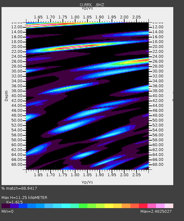
| Estimated Moho Depth: |
11.25 km |
| Estimated Crust Vp/Vs: |
1.62 |
| Assumed Crust Vp: |
6.276 km/s |
| Estimated Crust Vs: |
3.886 km/s |
| Estimated Crust Poisson's Ratio: |
0.19 |
|
| Radial Match: |
88.9417 % |
| Radial Bump: |
400 |
| Transverse Match: |
90.044556 % |
| Transverse Bump: |
400 |
| SOD ConfigId: |
414626 |
| Insert Time: |
2012-01-23 12:59:21.542 +0000 |
| GWidth: |
2.5 |
| Max Bumps: |
400 |
| Tol: |
0.001 |
|
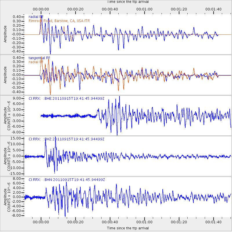
Signal To Noise
| Channel | StoN | STA | LTA |
| CI:RRX: :BHZ:20110915T19:41:45.94499Z | 6.894028 | 4.94461E-6 | 7.1723093E-7 |
| CI:RRX: :BHN:20110915T19:41:45.94499Z | 2.7104912 | 1.5204054E-6 | 5.6093353E-7 |
| CI:RRX: :BHE:20110915T19:41:45.94499Z | 3.6173553 | 1.589799E-6 | 4.394921E-7 |
| Arrivals |
| Ps | 1.1 SECOND |
| PpPs | 4.6 SECOND |
| PsPs/PpSs | 5.7 SECOND |


