You are here: Home > Network List > TA - USArray Transportable Network (new EarthScope stations) Stations List
> Station L02D Cave Junction, OR, USA > Earthquake Result Viewer
L02D Cave Junction, OR, USA - Earthquake Result Viewer
| Earthquake location: |
Fiji Islands Region |
| Earthquake latitude/longitude: |
-21.6/-179.5 |
| Earthquake time(UTC): |
2011/09/15 (258) 19:31:04 GMT |
| Earthquake Depth: |
645 km |
| Earthquake Magnitude: |
6.1 MB, 7.3 MW, 7.3 MW |
| Earthquake Catalog/Contributor: |
WHDF/NEIC |
|
| Network: |
TA USArray Transportable Network (new EarthScope stations) |
| Station: |
L02D Cave Junction, OR, USA |
| Lat/Lon: |
42.16 N/123.60 W |
| Elevation: |
458 m |
|
| Distance: |
81.8 deg |
| Az: |
38.481 deg |
| Baz: |
231.147 deg |
| Ray Param: |
0.045342874 |
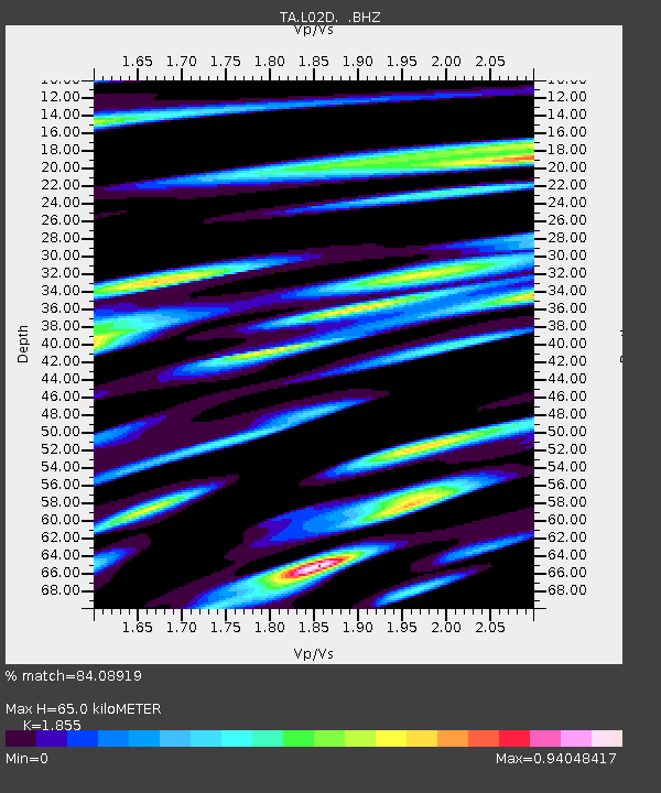
| Estimated Moho Depth: |
65.0 km |
| Estimated Crust Vp/Vs: |
1.86 |
| Assumed Crust Vp: |
6.522 km/s |
| Estimated Crust Vs: |
3.516 km/s |
| Estimated Crust Poisson's Ratio: |
0.30 |
|
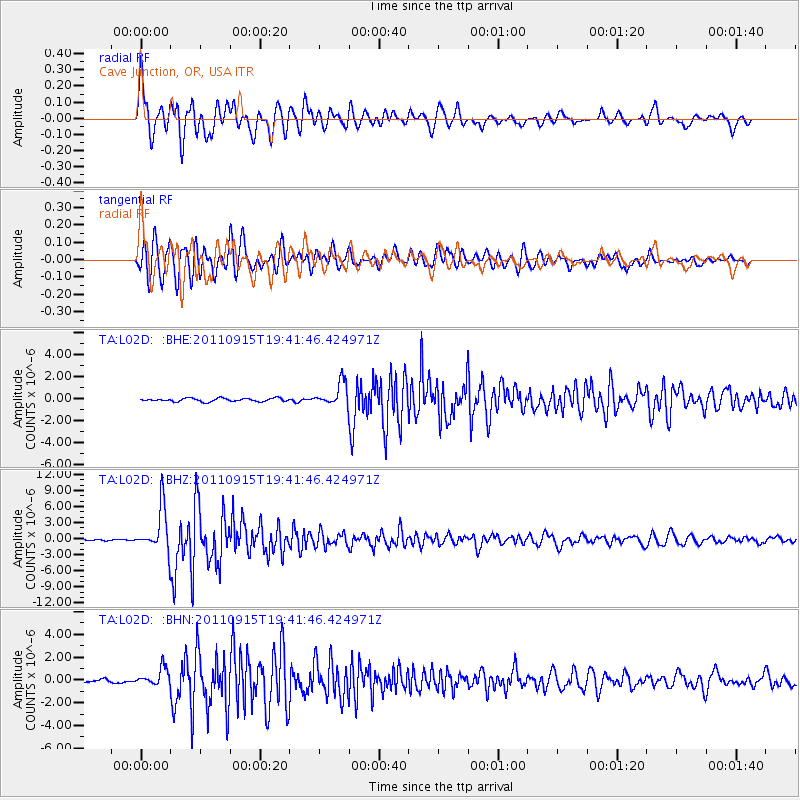
| Radial Match: |
84.08919 % |
| Radial Bump: |
400 |
| Transverse Match: |
86.892265 % |
| Transverse Bump: |
400 |
| SOD ConfigId: |
414626 |
| Insert Time: |
2012-01-23 13:08:02.169 +0000 |
| GWidth: |
2.5 |
| Max Bumps: |
400 |
| Tol: |
0.001 |
|
Signal To Noise
| Channel | StoN | STA | LTA |
| TA:L02D: :BHZ:20110915T19:41:46.424971Z | 33.96625 | 4.1226003E-6 | 1.2137343E-7 |
| TA:L02D: :BHN:20110915T19:41:46.424971Z | 5.3099327 | 7.4023063E-7 | 1.394049E-7 |
| TA:L02D: :BHE:20110915T19:41:46.424971Z | 7.368057 | 1.0597088E-6 | 1.4382474E-7 |
| Arrivals |
| Ps | 8.7 SECOND |
| PpPs | 28 SECOND |
| PsPs/PpSs | 37 SECOND |


