You are here: Home > Network List > TA - USArray Transportable Network (new EarthScope stations) Stations List
> Station 334A Lometa, TX, USA > Earthquake Result Viewer
334A Lometa, TX, USA - Earthquake Result Viewer
| Earthquake location: |
Fiji Islands Region |
| Earthquake latitude/longitude: |
-21.6/-179.5 |
| Earthquake time(UTC): |
2011/09/15 (258) 19:31:04 GMT |
| Earthquake Depth: |
645 km |
| Earthquake Magnitude: |
6.1 MB, 7.3 MW, 7.3 MW |
| Earthquake Catalog/Contributor: |
WHDF/NEIC |
|
| Network: |
TA USArray Transportable Network (new EarthScope stations) |
| Station: |
334A Lometa, TX, USA |
| Lat/Lon: |
31.33 N/98.24 W |
| Elevation: |
389 m |
|
| Distance: |
94.0 deg |
| Az: |
57.979 deg |
| Baz: |
247.221 deg |
| Ray Param: |
0.04051759 |
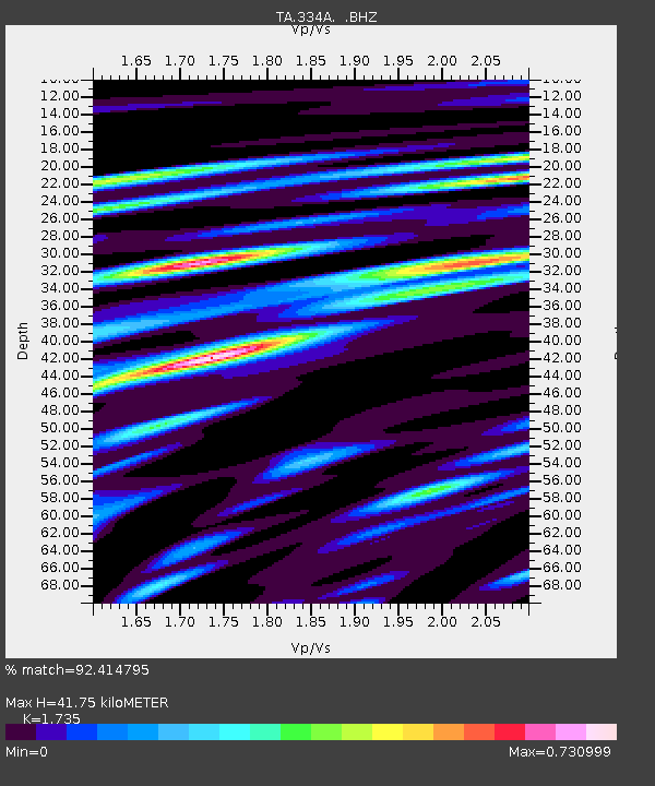
| Estimated Moho Depth: |
41.75 km |
| Estimated Crust Vp/Vs: |
1.74 |
| Assumed Crust Vp: |
6.498 km/s |
| Estimated Crust Vs: |
3.745 km/s |
| Estimated Crust Poisson's Ratio: |
0.25 |
|
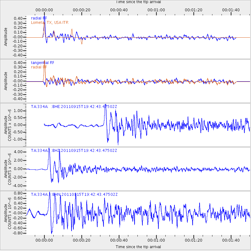
| Radial Match: |
92.414795 % |
| Radial Bump: |
400 |
| Transverse Match: |
87.25775 % |
| Transverse Bump: |
400 |
| SOD ConfigId: |
414626 |
| Insert Time: |
2012-01-23 13:08:18.558 +0000 |
| GWidth: |
2.5 |
| Max Bumps: |
400 |
| Tol: |
0.001 |
|
Signal To Noise
| Channel | StoN | STA | LTA |
| TA:334A: :BHZ:20110915T19:42:43.47502Z | 25.775576 | 2.0319771E-6 | 7.883344E-8 |
| TA:334A: :BHN:20110915T19:42:43.47502Z | 6.961141 | 4.094375E-7 | 5.8817584E-8 |
| TA:334A: :BHE:20110915T19:42:43.47502Z | 9.967628 | 6.713597E-7 | 6.735401E-8 |
| Arrivals |
| Ps | 4.8 SECOND |
| PpPs | 17 SECOND |
| PsPs/PpSs | 22 SECOND |


