You are here: Home > Network List > TA - USArray Transportable Network (new EarthScope stations) Stations List
> Station 234A Clairette, TX, USA > Earthquake Result Viewer
234A Clairette, TX, USA - Earthquake Result Viewer

| Earthquake location: |
Fiji Islands Region |
| Earthquake latitude/longitude: |
-21.6/-179.5 |
| Earthquake time(UTC): |
2011/09/15 (258) 19:31:04 GMT |
| Earthquake Depth: |
645 km |
| Earthquake Magnitude: |
6.1 MB, 7.3 MW, 7.3 MW |
| Earthquake Catalog/Contributor: |
WHDF/NEIC |
|
| Network: |
TA USArray Transportable Network (new EarthScope stations) |
| Station: |
234A Clairette, TX, USA |
| Lat/Lon: |
32.00 N/98.14 W |
| Elevation: |
358 m |
|
| Distance: |
94.3 deg |
| Az: |
57.394 deg |
| Baz: |
247.316 deg |
| Ray Param: |
0.040417764 |
| Estimated Moho Depth: |
29.5 km |
| Estimated Crust Vp/Vs: |
1.93 |
| Assumed Crust Vp: |
6.426 km/s |
| Estimated Crust Vs: |
3.334 km/s |
| Estimated Crust Poisson's Ratio: |
0.32 |
|
| Radial Match: |
88.72686 % |
| Radial Bump: |
400 |
| Transverse Match: |
73.023994 % |
| Transverse Bump: |
400 |
| SOD ConfigId: |
414626 |
| Insert Time: |
2012-01-23 13:08:45.270 +0000 |
| GWidth: |
2.5 |
| Max Bumps: |
400 |
| Tol: |
0.001 |
|
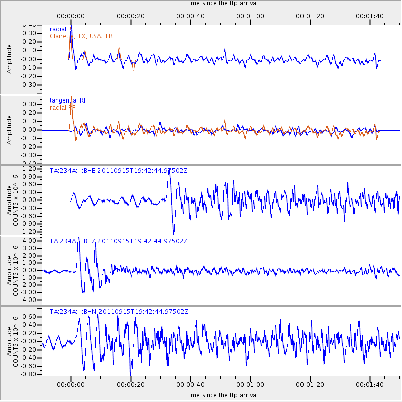
Signal To Noise
| Channel | StoN | STA | LTA |
| TA:234A: :BHZ:20110915T19:42:44.97502Z | 19.872158 | 1.982999E-6 | 9.978781E-8 |
| TA:234A: :BHN:20110915T19:42:44.97502Z | 3.772849 | 3.1444483E-7 | 8.334413E-8 |
| TA:234A: :BHE:20110915T19:42:44.97502Z | 5.356106 | 6.100071E-7 | 1.1389004E-7 |
| Arrivals |
| Ps | 4.3 SECOND |
| PpPs | 13 SECOND |
| PsPs/PpSs | 18 SECOND |


