You are here: Home > Network List > TA - USArray Transportable Network (new EarthScope stations) Stations List
> Station 535A Dale, TX, USA > Earthquake Result Viewer
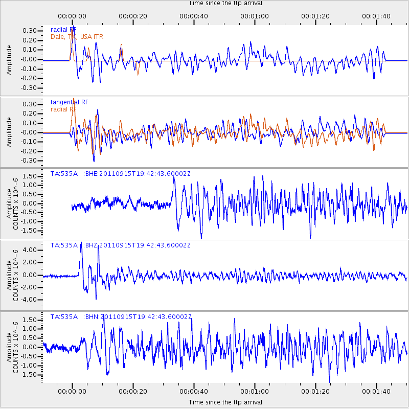
535A Dale, TX, USA - Earthquake Result Viewer
*The percent match for this event was below the threshold and hence no stack was calculated.
| Earthquake location: |
Fiji Islands Region |
| Earthquake latitude/longitude: |
-21.6/-179.5 |
| Earthquake time(UTC): |
2011/09/15 (258) 19:31:04 GMT |
| Earthquake Depth: |
645 km |
| Earthquake Magnitude: |
6.1 MB, 7.3 MW, 7.3 MW |
| Earthquake Catalog/Contributor: |
WHDF/NEIC |
|
| Network: |
TA USArray Transportable Network (new EarthScope stations) |
| Station: |
535A Dale, TX, USA |
| Lat/Lon: |
30.03 N/97.57 W |
| Elevation: |
170 m |
|
| Distance: |
94.0 deg |
| Az: |
59.403 deg |
| Baz: |
247.462 deg |
| Ray Param: |
$rayparam |
*The percent match for this event was below the threshold and hence was not used in the summary stack. |
|
| Radial Match: |
74.22026 % |
| Radial Bump: |
400 |
| Transverse Match: |
84.25334 % |
| Transverse Bump: |
400 |
| SOD ConfigId: |
414626 |
| Insert Time: |
2012-01-23 13:09:26.097 +0000 |
| GWidth: |
2.5 |
| Max Bumps: |
400 |
| Tol: |
0.001 |
|
Signal To Noise
| Channel | StoN | STA | LTA |
| TA:535A: :BHZ:20110915T19:42:43.60002Z | 21.771645 | 1.984167E-6 | 9.113538E-8 |
| TA:535A: :BHN:20110915T19:42:43.60002Z | 1.6968485 | 2.8695936E-7 | 1.6911312E-7 |
| TA:535A: :BHE:20110915T19:42:43.60002Z | 3.1920002 | 6.1129765E-7 | 1.9150927E-7 |
| Arrivals |
| Ps | |
| PpPs | |
| PsPs/PpSs | |


