You are here: Home > Network List > TA - USArray Transportable Network (new EarthScope stations) Stations List
> Station 437A Phaontom Ranch, North Zulch, TX, USA > Earthquake Result Viewer
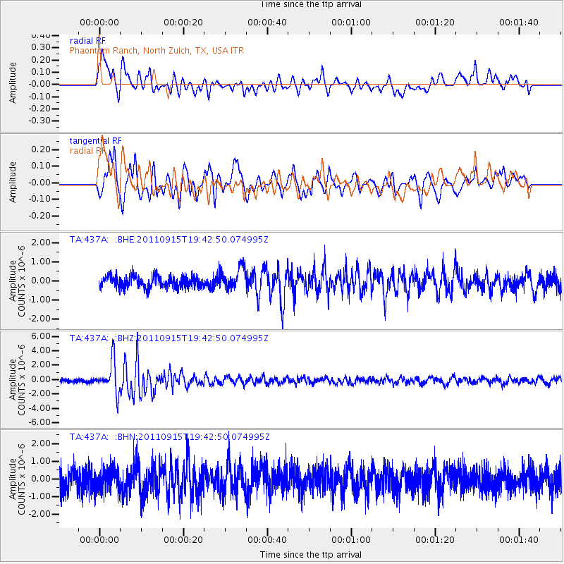
437A Phaontom Ranch, North Zulch, TX, USA - Earthquake Result Viewer
| Earthquake location: |
Fiji Islands Region |
| Earthquake latitude/longitude: |
-21.6/-179.5 |
| Earthquake time(UTC): |
2011/09/15 (258) 19:31:04 GMT |
| Earthquake Depth: |
645 km |
| Earthquake Magnitude: |
6.1 MB, 7.3 MW, 7.3 MW |
| Earthquake Catalog/Contributor: |
WHDF/NEIC |
|
| Network: |
TA USArray Transportable Network (new EarthScope stations) |
| Station: |
437A Phaontom Ranch, North Zulch, TX, USA |
| Lat/Lon: |
30.83 N/96.14 W |
| Elevation: |
95 m |
|
| Distance: |
95.4 deg |
| Az: |
59.13 deg |
| Baz: |
248.206 deg |
| Ray Param: |
0.040079888 |
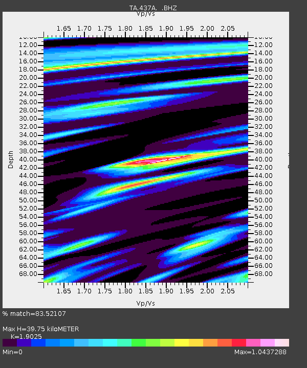
| Estimated Moho Depth: |
39.75 km |
| Estimated Crust Vp/Vs: |
1.90 |
| Assumed Crust Vp: |
6.347 km/s |
| Estimated Crust Vs: |
3.336 km/s |
| Estimated Crust Poisson's Ratio: |
0.31 |
|
| Radial Match: |
83.52107 % |
| Radial Bump: |
400 |
| Transverse Match: |
73.704346 % |
| Transverse Bump: |
400 |
| SOD ConfigId: |
414626 |
| Insert Time: |
2012-01-23 13:10:59.550 +0000 |
| GWidth: |
2.5 |
| Max Bumps: |
400 |
| Tol: |
0.001 |
|
Signal To Noise
| Channel | StoN | STA | LTA |
| TA:437A: :BHZ:20110915T19:42:50.074995Z | 11.643677 | 2.2436657E-6 | 1.9269392E-7 |
| TA:437A: :BHN:20110915T19:42:50.074995Z | 1.0605223 | 6.1266195E-7 | 5.7769836E-7 |
| TA:437A: :BHE:20110915T19:42:50.074995Z | 1.8968471 | 5.587377E-7 | 2.945613E-7 |
| Arrivals |
| Ps | 5.8 SECOND |
| PpPs | 18 SECOND |
| PsPs/PpSs | 24 SECOND |


