You are here: Home > Network List > TA - USArray Transportable Network (new EarthScope stations) Stations List
> Station L04D Klamath Falls, OR, USA > Earthquake Result Viewer
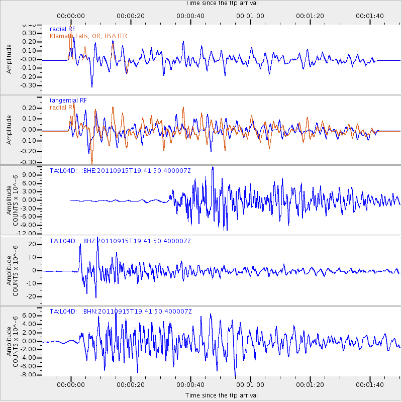
L04D Klamath Falls, OR, USA - Earthquake Result Viewer
*The percent match for this event was below the threshold and hence no stack was calculated.
| Earthquake location: |
Fiji Islands Region |
| Earthquake latitude/longitude: |
-21.6/-179.5 |
| Earthquake time(UTC): |
2011/09/15 (258) 19:31:04 GMT |
| Earthquake Depth: |
645 km |
| Earthquake Magnitude: |
6.1 MB, 7.3 MW, 7.3 MW |
| Earthquake Catalog/Contributor: |
WHDF/NEIC |
|
| Network: |
TA USArray Transportable Network (new EarthScope stations) |
| Station: |
L04D Klamath Falls, OR, USA |
| Lat/Lon: |
42.22 N/122.30 W |
| Elevation: |
1437 m |
|
| Distance: |
82.6 deg |
| Az: |
39.038 deg |
| Baz: |
232.092 deg |
| Ray Param: |
$rayparam |
*The percent match for this event was below the threshold and hence was not used in the summary stack. |
|
| Radial Match: |
85.1969 % |
| Radial Bump: |
400 |
| Transverse Match: |
76.02552 % |
| Transverse Bump: |
400 |
| SOD ConfigId: |
414626 |
| Insert Time: |
2012-01-23 13:11:38.544 +0000 |
| GWidth: |
2.5 |
| Max Bumps: |
400 |
| Tol: |
0.001 |
|
Signal To Noise
| Channel | StoN | STA | LTA |
| TA:L04D: :BHZ:20110915T19:41:50.400007Z | 33.57885 | 6.406171E-6 | 1.9077996E-7 |
| TA:L04D: :BHN:20110915T19:41:50.400007Z | 5.3015003 | 8.7101927E-7 | 1.6429674E-7 |
| TA:L04D: :BHE:20110915T19:41:50.400007Z | 6.943232 | 1.22365E-6 | 1.7623636E-7 |
| Arrivals |
| Ps | |
| PpPs | |
| PsPs/PpSs | |


