You are here: Home > Network List > TA - USArray Transportable Network (new EarthScope stations) Stations List
> Station D03D Eldon, WA, USA > Earthquake Result Viewer
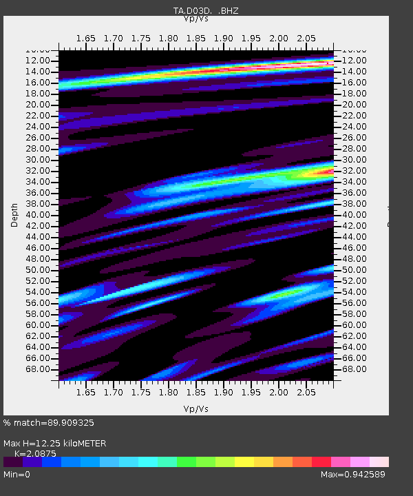
D03D Eldon, WA, USA - Earthquake Result Viewer
| Earthquake location: |
Fiji Islands Region |
| Earthquake latitude/longitude: |
-21.6/-179.5 |
| Earthquake time(UTC): |
2011/09/15 (258) 19:31:04 GMT |
| Earthquake Depth: |
645 km |
| Earthquake Magnitude: |
6.1 MB, 7.3 MW, 7.3 MW |
| Earthquake Catalog/Contributor: |
WHDF/NEIC |
|
| Network: |
TA USArray Transportable Network (new EarthScope stations) |
| Station: |
D03D Eldon, WA, USA |
| Lat/Lon: |
47.53 N/123.09 W |
| Elevation: |
262 m |
|
| Distance: |
85.5 deg |
| Az: |
34.502 deg |
| Baz: |
231.066 deg |
| Ray Param: |
0.042834934 |
| Estimated Moho Depth: |
12.25 km |
| Estimated Crust Vp/Vs: |
2.09 |
| Assumed Crust Vp: |
6.566 km/s |
| Estimated Crust Vs: |
3.145 km/s |
| Estimated Crust Poisson's Ratio: |
0.35 |
|
| Radial Match: |
89.909325 % |
| Radial Bump: |
400 |
| Transverse Match: |
86.03255 % |
| Transverse Bump: |
400 |
| SOD ConfigId: |
414626 |
| Insert Time: |
2012-01-23 13:12:32.664 +0000 |
| GWidth: |
2.5 |
| Max Bumps: |
400 |
| Tol: |
0.001 |
|

Signal To Noise
| Channel | StoN | STA | LTA |
| TA:D03D: :BHZ:20110915T19:42:04.35002Z | 37.7992 | 3.4857164E-6 | 9.221668E-8 |
| TA:D03D: :BHN:20110915T19:42:04.35002Z | 8.282586 | 9.393264E-7 | 1.1340979E-7 |
| TA:D03D: :BHE:20110915T19:42:04.35002Z | 6.2937016 | 5.4880815E-7 | 8.719958E-8 |
| Arrivals |
| Ps | 2.1 SECOND |
| PpPs | 5.6 SECOND |
| PsPs/PpSs | 7.7 SECOND |


