You are here: Home > Network List > TA - USArray Transportable Network (new EarthScope stations) Stations List
> Station O03E Paynes Creek, CA, USA > Earthquake Result Viewer
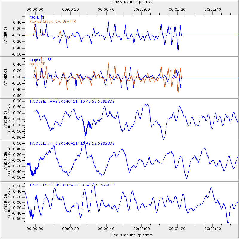
O03E Paynes Creek, CA, USA - Earthquake Result Viewer
*The percent match for this event was below the threshold and hence no stack was calculated.
| Earthquake location: |
Solomon Islands |
| Earthquake latitude/longitude: |
-6.9/155.2 |
| Earthquake time(UTC): |
2014/04/11 (101) 10:30:32 GMT |
| Earthquake Depth: |
41 km |
| Earthquake Magnitude: |
5.1 mb |
| Earthquake Catalog/Contributor: |
ISC/ISC |
|
| Network: |
TA USArray Transportable Network (new EarthScope stations) |
| Station: |
O03E Paynes Creek, CA, USA |
| Lat/Lon: |
40.29 N/121.80 W |
| Elevation: |
967 m |
|
| Distance: |
89.1 deg |
| Az: |
49.403 deg |
| Baz: |
260.27 deg |
| Ray Param: |
$rayparam |
*The percent match for this event was below the threshold and hence was not used in the summary stack. |
|
| Radial Match: |
83.00872 % |
| Radial Bump: |
400 |
| Transverse Match: |
68.042946 % |
| Transverse Bump: |
400 |
| SOD ConfigId: |
3390531 |
| Insert Time: |
2019-04-11 07:03:38.050 +0000 |
| GWidth: |
2.5 |
| Max Bumps: |
400 |
| Tol: |
0.001 |
|
Signal To Noise
| Channel | StoN | STA | LTA |
| TA:O03E: :HHZ:20140411T10:42:52.599983Z | 0.79228026 | 2.669851E-7 | 3.3698313E-7 |
| TA:O03E: :HHN:20140411T10:42:52.599983Z | 1.6200082 | 3.1563798E-7 | 1.9483726E-7 |
| TA:O03E: :HHE:20140411T10:42:52.599983Z | 1.1659467 | 3.384762E-7 | 2.903016E-7 |
| Arrivals |
| Ps | |
| PpPs | |
| PsPs/PpSs | |


