You are here: Home > Network List > TW - Broadband Array in Taiwan for Seismology Stations List
> Station SSLB SUANG-LONG > Earthquake Result Viewer
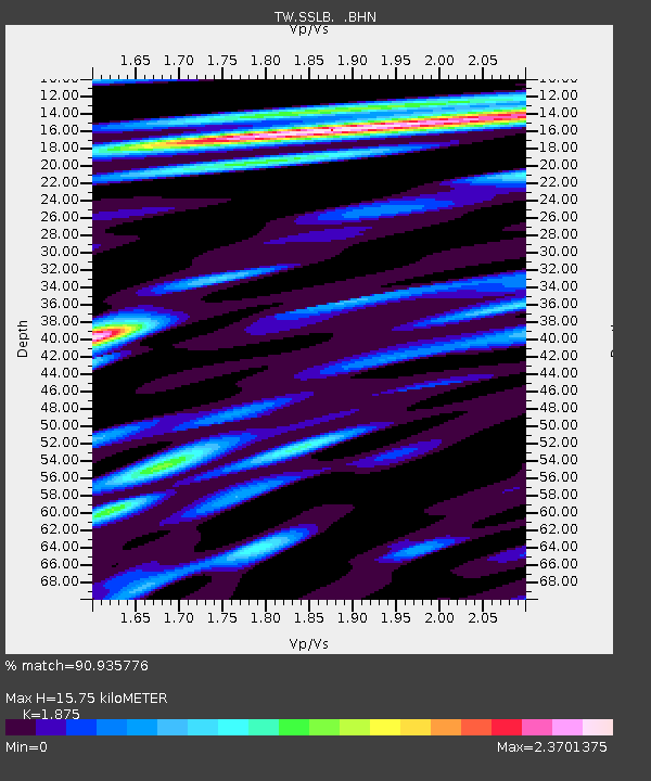
SSLB SUANG-LONG - Earthquake Result Viewer
| Earthquake location: |
Fiji Islands Region |
| Earthquake latitude/longitude: |
-21.6/-179.5 |
| Earthquake time(UTC): |
2011/09/15 (258) 19:31:04 GMT |
| Earthquake Depth: |
645 km |
| Earthquake Magnitude: |
6.1 MB, 7.3 MW, 7.3 MW |
| Earthquake Catalog/Contributor: |
WHDF/NEIC |
|
| Network: |
TW Broadband Array in Taiwan for Seismology |
| Station: |
SSLB SUANG-LONG |
| Lat/Lon: |
23.79 N/120.95 E |
| Elevation: |
450 m |
|
| Distance: |
73.4 deg |
| Az: |
304.54 deg |
| Baz: |
123.199 deg |
| Ray Param: |
0.05081982 |
| Estimated Moho Depth: |
15.75 km |
| Estimated Crust Vp/Vs: |
1.88 |
| Assumed Crust Vp: |
6.461 km/s |
| Estimated Crust Vs: |
3.446 km/s |
| Estimated Crust Poisson's Ratio: |
0.30 |
|
| Radial Match: |
90.935776 % |
| Radial Bump: |
400 |
| Transverse Match: |
80.1505 % |
| Transverse Bump: |
400 |
| SOD ConfigId: |
414626 |
| Insert Time: |
2012-01-23 13:13:23.418 +0000 |
| GWidth: |
2.5 |
| Max Bumps: |
400 |
| Tol: |
0.001 |
|

Signal To Noise
| Channel | StoN | STA | LTA |
| TW:SSLB: :BHZ:20110915T19:41:01.720015Z | 33.177376 | 6.7616843E-6 | 2.0380409E-7 |
| TW:SSLB: :BHN:20110915T19:41:01.720015Z | 34.62029 | 3.659259E-6 | 1.05696955E-7 |
| TW:SSLB: :BHE:20110915T19:41:01.720015Z | 26.279982 | 3.0482558E-6 | 1.1599155E-7 |
| Arrivals |
| Ps | 2.2 SECOND |
| PpPs | 6.8 SECOND |
| PsPs/PpSs | 9.0 SECOND |


