You are here: Home > Network List > UW - Pacific Northwest Regional Seismic Network Stations List
> Station YACT Amboy, WA, USA > Earthquake Result Viewer
YACT Amboy, WA, USA - Earthquake Result Viewer
| Earthquake location: |
Fiji Islands Region |
| Earthquake latitude/longitude: |
-21.6/-179.5 |
| Earthquake time(UTC): |
2011/09/15 (258) 19:31:04 GMT |
| Earthquake Depth: |
645 km |
| Earthquake Magnitude: |
6.1 MB, 7.3 MW, 7.3 MW |
| Earthquake Catalog/Contributor: |
WHDF/NEIC |
|
| Network: |
UW Pacific Northwest Regional Seismic Network |
| Station: |
YACT Amboy, WA, USA |
| Lat/Lon: |
45.93 N/122.42 W |
| Elevation: |
211 m |
|
| Distance: |
84.8 deg |
| Az: |
36.047 deg |
| Baz: |
231.684 deg |
| Ray Param: |
0.043284047 |
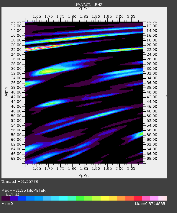
| Estimated Moho Depth: |
21.25 km |
| Estimated Crust Vp/Vs: |
1.64 |
| Assumed Crust Vp: |
6.566 km/s |
| Estimated Crust Vs: |
4.004 km/s |
| Estimated Crust Poisson's Ratio: |
0.20 |
|
| Radial Match: |
91.25778 % |
| Radial Bump: |
400 |
| Transverse Match: |
87.3646 % |
| Transverse Bump: |
400 |
| SOD ConfigId: |
414626 |
| Insert Time: |
2012-01-23 13:15:02.939 +0000 |
| GWidth: |
2.5 |
| Max Bumps: |
400 |
| Tol: |
0.001 |
|
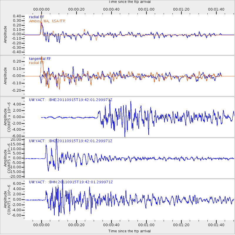
Signal To Noise
| Channel | StoN | STA | LTA |
| UW:YACT: :BHZ:20110915T19:42:01.299971Z | 84.13612 | 6.496334E-6 | 7.721219E-8 |
| UW:YACT: :BHN:20110915T19:42:01.299971Z | 14.782175 | 1.54549E-6 | 1.0455092E-7 |
| UW:YACT: :BHE:20110915T19:42:01.299971Z | 8.030535 | 1.0452194E-6 | 1.3015564E-7 |
| Arrivals |
| Ps | 2.1 SECOND |
| PpPs | 8.3 SECOND |
| PsPs/PpSs | 10 SECOND |


