You are here: Home > Network List > UW - Pacific Northwest Regional Seismic Network Stations List
> Station MRBL Marblemount, WA, USA > Earthquake Result Viewer
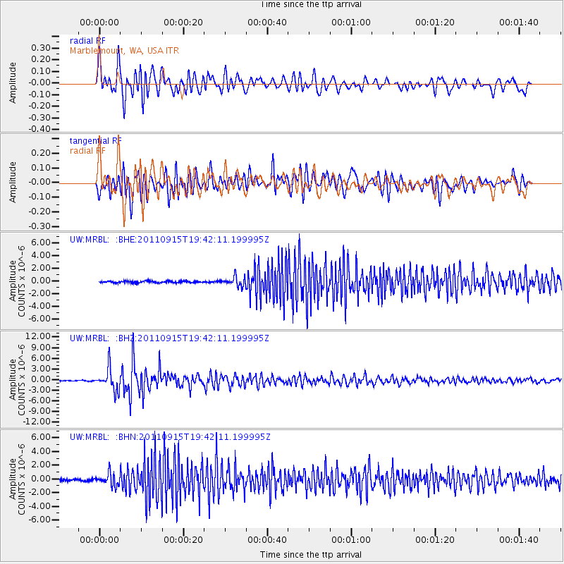
MRBL Marblemount, WA, USA - Earthquake Result Viewer
*The percent match for this event was below the threshold and hence no stack was calculated.
| Earthquake location: |
Fiji Islands Region |
| Earthquake latitude/longitude: |
-21.6/-179.5 |
| Earthquake time(UTC): |
2011/09/15 (258) 19:31:04 GMT |
| Earthquake Depth: |
645 km |
| Earthquake Magnitude: |
6.1 MB, 7.3 MW, 7.3 MW |
| Earthquake Catalog/Contributor: |
WHDF/NEIC |
|
| Network: |
UW Pacific Northwest Regional Seismic Network |
| Station: |
MRBL Marblemount, WA, USA |
| Lat/Lon: |
48.52 N/121.48 W |
| Elevation: |
75 m |
|
| Distance: |
86.9 deg |
| Az: |
34.398 deg |
| Baz: |
232.249 deg |
| Ray Param: |
$rayparam |
*The percent match for this event was below the threshold and hence was not used in the summary stack. |
|
| Radial Match: |
79.290794 % |
| Radial Bump: |
400 |
| Transverse Match: |
81.34869 % |
| Transverse Bump: |
400 |
| SOD ConfigId: |
414626 |
| Insert Time: |
2012-01-23 13:15:05.856 +0000 |
| GWidth: |
2.5 |
| Max Bumps: |
400 |
| Tol: |
0.001 |
|
Signal To Noise
| Channel | StoN | STA | LTA |
| UW:MRBL: :BHZ:20110915T19:42:11.199995Z | 38.7709 | 3.222821E-6 | 8.312474E-8 |
| UW:MRBL: :BHN:20110915T19:42:11.199995Z | 7.3286543 | 9.0693663E-7 | 1.2375214E-7 |
| UW:MRBL: :BHE:20110915T19:42:11.199995Z | 5.331241 | 7.4541686E-7 | 1.3982051E-7 |
| Arrivals |
| Ps | |
| PpPs | |
| PsPs/PpSs | |


