You are here: Home > Network List > UW - Pacific Northwest Regional Seismic Network Stations List
> Station RADR Rader Ridge, WA > Earthquake Result Viewer
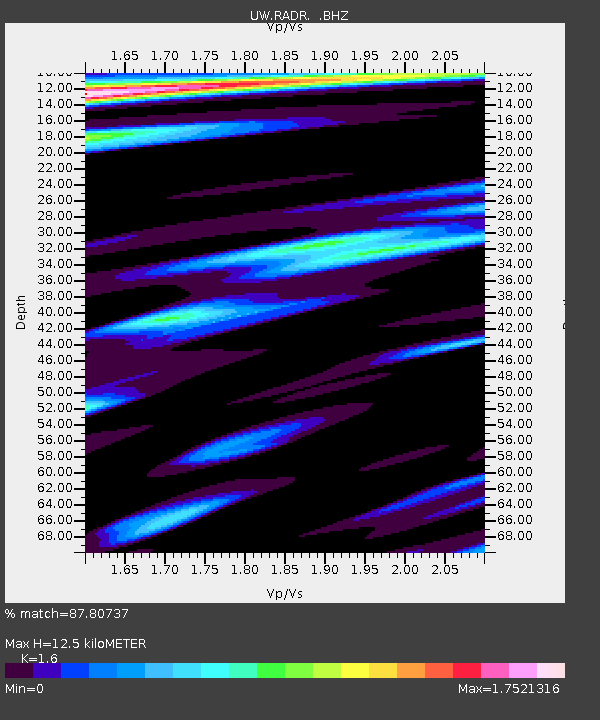
RADR Rader Ridge, WA - Earthquake Result Viewer
| Earthquake location: |
Fiji Islands Region |
| Earthquake latitude/longitude: |
-21.6/-179.5 |
| Earthquake time(UTC): |
2011/09/15 (258) 19:31:04 GMT |
| Earthquake Depth: |
645 km |
| Earthquake Magnitude: |
6.1 MB, 7.3 MW, 7.3 MW |
| Earthquake Catalog/Contributor: |
WHDF/NEIC |
|
| Network: |
UW Pacific Northwest Regional Seismic Network |
| Station: |
RADR Rader Ridge, WA |
| Lat/Lon: |
46.42 N/123.80 W |
| Elevation: |
568 m |
|
| Distance: |
84.4 deg |
| Az: |
35.06 deg |
| Baz: |
230.598 deg |
| Ray Param: |
0.043582518 |
| Estimated Moho Depth: |
12.5 km |
| Estimated Crust Vp/Vs: |
1.60 |
| Assumed Crust Vp: |
6.566 km/s |
| Estimated Crust Vs: |
4.104 km/s |
| Estimated Crust Poisson's Ratio: |
0.18 |
|
| Radial Match: |
87.80737 % |
| Radial Bump: |
400 |
| Transverse Match: |
79.66838 % |
| Transverse Bump: |
400 |
| SOD ConfigId: |
414626 |
| Insert Time: |
2012-01-23 13:16:51.510 +0000 |
| GWidth: |
2.5 |
| Max Bumps: |
400 |
| Tol: |
0.001 |
|

Signal To Noise
| Channel | StoN | STA | LTA |
| UW:RADR: :BHZ:20110915T19:41:59.18498Z | 22.050093 | 5.7314105E-6 | 2.5992682E-7 |
| UW:RADR: :BHN:20110915T19:41:59.18498Z | 4.154651 | 1.2481231E-6 | 3.0041585E-7 |
| UW:RADR: :BHE:20110915T19:41:59.18498Z | 4.0457053 | 1.5936123E-6 | 3.9390224E-7 |
| Arrivals |
| Ps | 1.2 SECOND |
| PpPs | 4.8 SECOND |
| PsPs/PpSs | 6.0 SECOND |


