You are here: Home > Network List > G - GEOSCOPE Stations List
> Station CLF Chambon la Foret observatory, France > Earthquake Result Viewer
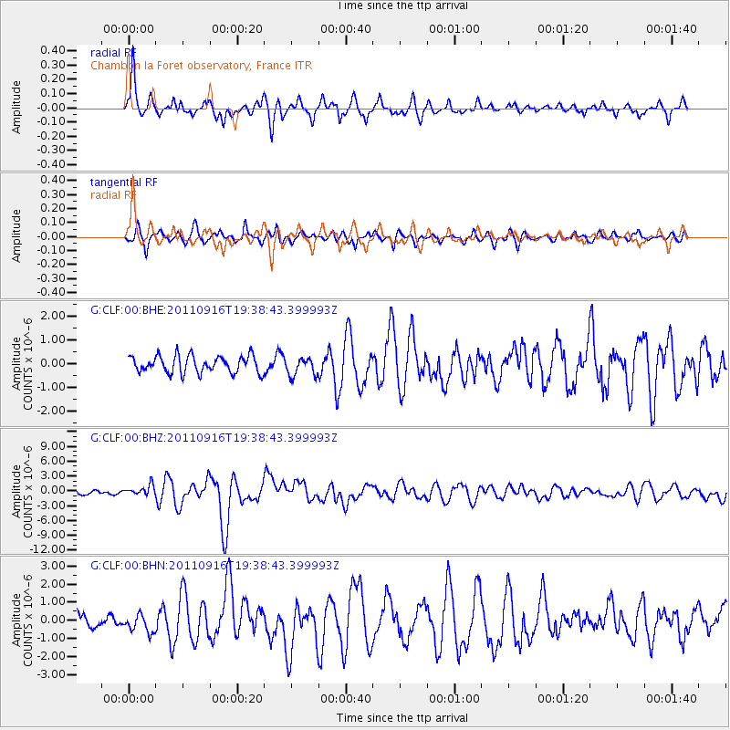
CLF Chambon la Foret observatory, France - Earthquake Result Viewer
*The percent match for this event was below the threshold and hence no stack was calculated.
| Earthquake location: |
Near East Coast Of Honshu, Japan |
| Earthquake latitude/longitude: |
40.3/142.8 |
| Earthquake time(UTC): |
2011/09/16 (259) 19:26:40 GMT |
| Earthquake Depth: |
35 km |
| Earthquake Magnitude: |
6.0 MB, 6.5 MS, 6.7 MW, 6.7 MW |
| Earthquake Catalog/Contributor: |
WHDF/NEIC |
|
| Network: |
G GEOSCOPE |
| Station: |
CLF Chambon la Foret observatory, France |
| Lat/Lon: |
48.03 N/2.26 E |
| Elevation: |
145 m |
|
| Distance: |
85.4 deg |
| Az: |
334.646 deg |
| Baz: |
29.214 deg |
| Ray Param: |
$rayparam |
*The percent match for this event was below the threshold and hence was not used in the summary stack. |
|
| Radial Match: |
79.04978 % |
| Radial Bump: |
353 |
| Transverse Match: |
72.199196 % |
| Transverse Bump: |
400 |
| SOD ConfigId: |
414626 |
| Insert Time: |
2012-01-23 13:43:56.164 +0000 |
| GWidth: |
2.5 |
| Max Bumps: |
400 |
| Tol: |
0.001 |
|
Signal To Noise
| Channel | StoN | STA | LTA |
| G:CLF:00:BHZ:20110916T19:38:43.399993Z | 2.2514057 | 1.0594479E-6 | 4.7057176E-7 |
| G:CLF:00:BHN:20110916T19:38:43.399993Z | 1.1194097 | 4.998525E-7 | 4.465322E-7 |
| G:CLF:00:BHE:20110916T19:38:43.399993Z | 1.1009234 | 3.9159403E-7 | 3.5569596E-7 |
| Arrivals |
| Ps | |
| PpPs | |
| PsPs/PpSs | |


