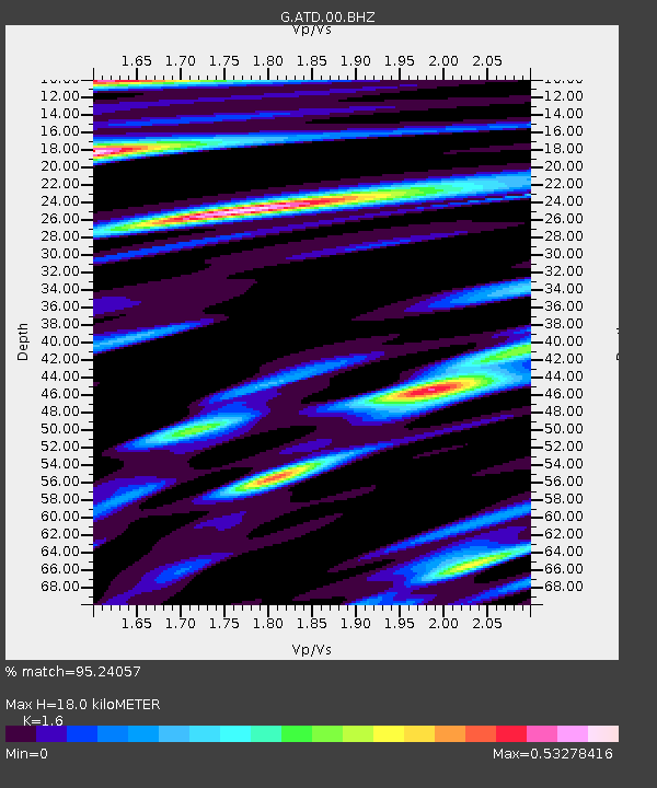
ATD Arta Cave - Arta, Republic of Djibouti - Earthquake Result Viewer
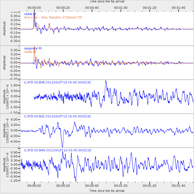
Earthquake location: Near East Coast Of Honshu, Japan
Earthquake latitude/longitude: 40.3/142.8
Earthquake time(UTC): 2011/09/16 (259) 19:26:40 GMT
Earthquake Depth: 35 km
Earthquake Magnitude: 6.0 MB, 6.5 MS, 6.7 MW, 6.7 MW
Earthquake Catalog/Contributor: WHDF/NEIC
Network: G GEOSCOPE
Station: ATD Arta Cave - Arta, Republic of Djibouti
Lat/Lon: 11.53 N/42.85 E
Elevation: 610 m
Distance: 90.1 deg
Az: 285.119 deg
Baz: 48.909 deg
Ray Param: 0.041694228
Estimated Moho Depth: 18.0 km
Estimated Crust Vp/Vs: 1.60
Assumed Crust Vp: 6.375 km/s
Estimated Crust Vs: 3.984 km/s
Estimated Crust Poisson's Ratio: 0.18
Radial Match: 95.24057 %
Radial Bump: 400
Transverse Match: 84.07271 %
Transverse Bump: 400
SOD ConfigId: 414626
Insert Time: 2012-01-23 13:43:59.116 +0000
GWidth: 2.5
Max Bumps: 400
Tol: 0.001

Signal To Noise

ChannelStoNSTALTA
G:ATD:00:BHZ:20110916T19:39:06.000029Z3.12333084.125112E-71.3207413E-7
G:ATD:00:BHN:20110916T19:39:06.000029Z0.91111241.4849432E-71.6298134E-7
G:ATD:00:BHE:20110916T19:39:06.000029Z1.21715012.0672705E-71.6984515E-7
Arrivals
Ps1.7 SECOND
PpPs7.2 SECOND
PsPs/PpSs8.9 SECOND