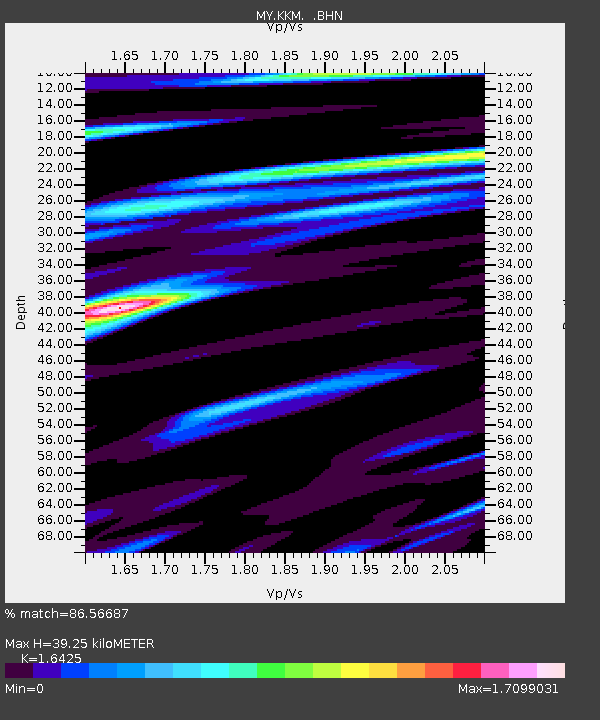
KKM Kota Kinabalu - Earthquake Result Viewer

Earthquake location: Near East Coast Of Honshu, Japan
Earthquake latitude/longitude: 40.3/142.8
Earthquake time(UTC): 2011/09/16 (259) 19:26:40 GMT
Earthquake Depth: 35 km
Earthquake Magnitude: 6.0 MB, 6.5 MS, 6.7 MW, 6.7 MW
Earthquake Catalog/Contributor: WHDF/NEIC
Network: MY Malaysian National Seismic Network
Station: KKM Kota Kinabalu
Lat/Lon: 6.04 N/116.21 E
Elevation: 830 m
Distance: 41.6 deg
Az: 222.073 deg
Baz: 31.032 deg
Ray Param: 0.07362409
Estimated Moho Depth: 39.25 km
Estimated Crust Vp/Vs: 1.64
Assumed Crust Vp: 6.048 km/s
Estimated Crust Vs: 3.682 km/s
Estimated Crust Poisson's Ratio: 0.21
Radial Match: 86.56687 %
Radial Bump: 400
Transverse Match: 83.734535 %
Transverse Bump: 400
SOD ConfigId: 414626
Insert Time: 2012-01-23 13:49:27.836 +0000
GWidth: 2.5
Max Bumps: 400
Tol: 0.001

Signal To Noise

ChannelStoNSTALTA
MY:KKM: :BHZ:20110916T19:33:55.019988Z5.85741669.36657E-71.5990958E-7
MY:KKM: :BHN:20110916T19:33:55.019988Z2.3143725.5006893E-72.3767524E-7
MY:KKM: :BHE:20110916T19:33:55.019988Z1.41717974.8397004E-73.4150224E-7
Arrivals
Ps4.4 SECOND
PpPs16 SECOND
PsPs/PpSs21 SECOND