You are here: Home > Network List > CI - Caltech Regional Seismic Network Stations List
> Station LGU Laguna Peak, California, USA > Earthquake Result Viewer
LGU Laguna Peak, California, USA - Earthquake Result Viewer
| Earthquake location: |
Caribbean Sea |
| Earthquake latitude/longitude: |
17.8/-81.6 |
| Earthquake time(UTC): |
2004/09/09 (253) 16:33:21 GMT |
| Earthquake Depth: |
25 km |
| Earthquake Magnitude: |
5.8 MB, 5.4 MS, 6.0 MW, 6.0 MW |
| Earthquake Catalog/Contributor: |
WHDF/NEIC |
|
| Network: |
CI Caltech Regional Seismic Network |
| Station: |
LGU Laguna Peak, California, USA |
| Lat/Lon: |
34.11 N/119.07 W |
| Elevation: |
381 m |
|
| Distance: |
37.2 deg |
| Az: |
303.338 deg |
| Baz: |
106.36 deg |
| Ray Param: |
0.07621826 |
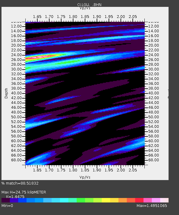
| Estimated Moho Depth: |
24.75 km |
| Estimated Crust Vp/Vs: |
1.65 |
| Assumed Crust Vp: |
6.1 km/s |
| Estimated Crust Vs: |
3.703 km/s |
| Estimated Crust Poisson's Ratio: |
0.21 |
|
| Radial Match: |
88.51832 % |
| Radial Bump: |
260 |
| Transverse Match: |
66.858086 % |
| Transverse Bump: |
285 |
| SOD ConfigId: |
2459 |
| Insert Time: |
2010-02-25 20:18:33.644 +0000 |
| GWidth: |
2.5 |
| Max Bumps: |
400 |
| Tol: |
0.001 |
|
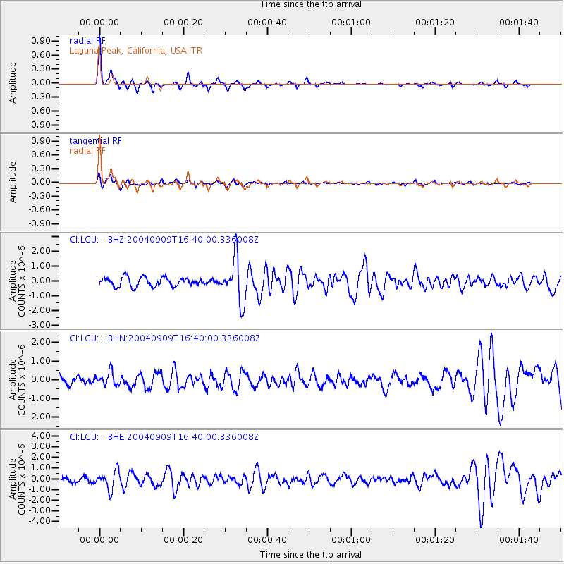
Signal To Noise
| Channel | StoN | STA | LTA |
| CI:LGU: :BHN:20040909T16:40:00.336008Z | 1.8219954 | 3.5878523E-7 | 1.9691885E-7 |
| CI:LGU: :BHE:20040909T16:40:00.336008Z | 4.382023 | 8.6111737E-7 | 1.9651138E-7 |
| CI:LGU: :BHZ:20040909T16:40:00.336008Z | 5.239915 | 1.5332297E-6 | 2.9260585E-7 |
| Arrivals |
| Ps | 2.8 SECOND |
| PpPs | 10 SECOND |
| PsPs/PpSs | 13 SECOND |


