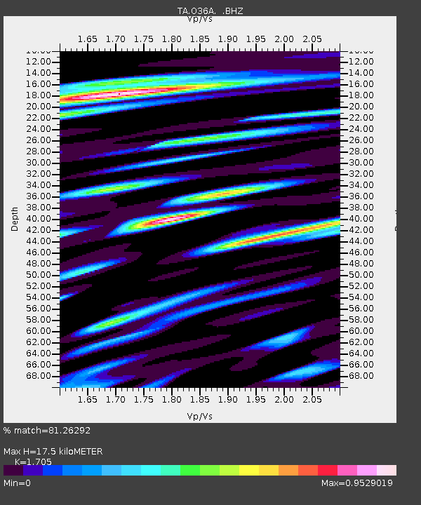
O36A Bolckow, MO, USA - Earthquake Result Viewer
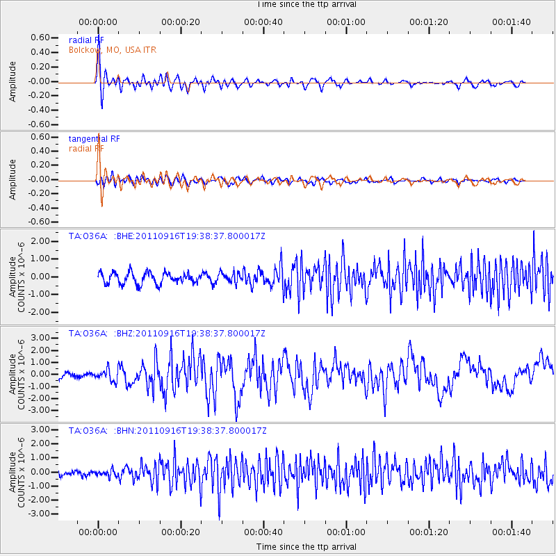
Earthquake location: Near East Coast Of Honshu, Japan
Earthquake latitude/longitude: 40.3/142.8
Earthquake time(UTC): 2011/09/16 (259) 19:26:40 GMT
Earthquake Depth: 35 km
Earthquake Magnitude: 6.0 MB, 6.5 MS, 6.7 MW, 6.7 MW
Earthquake Catalog/Contributor: WHDF/NEIC
Network: TA USArray Transportable Network (new EarthScope stations)
Station: O36A Bolckow, MO, USA
Lat/Lon: 40.13 N/94.96 W
Elevation: 306 m
Distance: 84.2 deg
Az: 40.667 deg
Baz: 319.433 deg
Ray Param: 0.045574255
Estimated Moho Depth: 17.5 km
Estimated Crust Vp/Vs: 1.71
Assumed Crust Vp: 6.498 km/s
Estimated Crust Vs: 3.811 km/s
Estimated Crust Poisson's Ratio: 0.24
Radial Match: 81.26292 %
Radial Bump: 400
Transverse Match: 63.277863 %
Transverse Bump: 400
SOD ConfigId: 414626
Insert Time: 2012-01-23 13:55:22.539 +0000
GWidth: 2.5
Max Bumps: 400
Tol: 0.001

Signal To Noise

ChannelStoNSTALTA
TA:O36A: :BHZ:20110916T19:38:37.800017Z1.45429544.856942E-73.3397217E-7
TA:O36A: :BHN:20110916T19:38:37.800017Z0.68768692.2169617E-73.223795E-7
TA:O36A: :BHE:20110916T19:38:37.800017Z0.90218062.8445652E-73.1529888E-7
Arrivals
Ps1.9 SECOND
PpPs7.1 SECOND
PsPs/PpSs9.0 SECOND