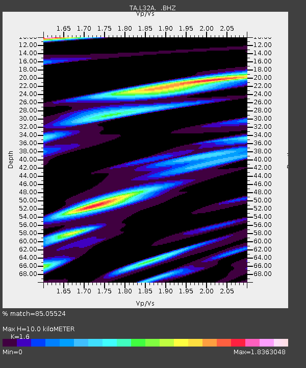
L32A Elgin, NE, USA - Earthquake Result Viewer

Earthquake location: Near East Coast Of Honshu, Japan
Earthquake latitude/longitude: 40.3/142.8
Earthquake time(UTC): 2011/09/16 (259) 19:26:40 GMT
Earthquake Depth: 35 km
Earthquake Magnitude: 6.0 MB, 6.5 MS, 6.7 MW, 6.7 MW
Earthquake Catalog/Contributor: WHDF/NEIC
Network: TA USArray Transportable Network (new EarthScope stations)
Station: L32A Elgin, NE, USA
Lat/Lon: 42.00 N/98.01 W
Elevation: 586 m
Distance: 81.3 deg
Az: 41.153 deg
Baz: 317.502 deg
Ray Param: 0.047621857
Estimated Moho Depth: 10.0 km
Estimated Crust Vp/Vs: 1.60
Assumed Crust Vp: 6.53 km/s
Estimated Crust Vs: 4.082 km/s
Estimated Crust Poisson's Ratio: 0.18
Radial Match: 85.05524 %
Radial Bump: 400
Transverse Match: 69.84199 %
Transverse Bump: 400
SOD ConfigId: 414626
Insert Time: 2012-01-23 13:57:11.650 +0000
GWidth: 2.5
Max Bumps: 400
Tol: 0.001

Signal To Noise

ChannelStoNSTALTA
TA:L32A: :BHZ:20110916T19:38:22.675017Z2.63479925.9313385E-72.2511539E-7
TA:L32A: :BHN:20110916T19:38:22.675017Z1.22719494.4376102E-73.61606E-7
TA:L32A: :BHE:20110916T19:38:22.675017Z0.62286573.1564645E-75.067649E-7
Arrivals
Ps0.9 SECOND
PpPs3.9 SECOND
PsPs/PpSs4.8 SECOND