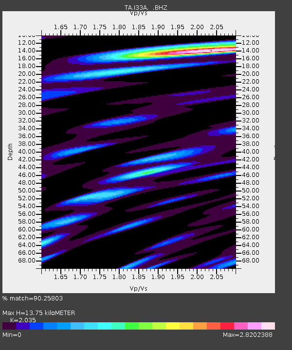
I33A Coleman, SD, USA - Earthquake Result Viewer

Earthquake location: Near East Coast Of Honshu, Japan
Earthquake latitude/longitude: 40.3/142.8
Earthquake time(UTC): 2011/09/16 (259) 19:26:40 GMT
Earthquake Depth: 35 km
Earthquake Magnitude: 6.0 MB, 6.5 MS, 6.7 MW, 6.7 MW
Earthquake Catalog/Contributor: WHDF/NEIC
Network: TA USArray Transportable Network (new EarthScope stations)
Station: I33A Coleman, SD, USA
Lat/Lon: 44.05 N/96.80 W
Elevation: 509 m
Distance: 80.4 deg
Az: 39.098 deg
Baz: 317.998 deg
Ray Param: 0.048252083
Estimated Moho Depth: 13.75 km
Estimated Crust Vp/Vs: 2.04
Assumed Crust Vp: 6.552 km/s
Estimated Crust Vs: 3.22 km/s
Estimated Crust Poisson's Ratio: 0.34
Radial Match: 90.25803 %
Radial Bump: 400
Transverse Match: 80.02623 %
Transverse Bump: 400
SOD ConfigId: 414626
Insert Time: 2012-01-23 13:58:05.415 +0000
GWidth: 2.5
Max Bumps: 400
Tol: 0.001

Signal To Noise

ChannelStoNSTALTA
TA:I33A: :BHZ:20110916T19:38:17.82498Z2.36084946.265309E-72.6538368E-7
TA:I33A: :BHN:20110916T19:38:17.82498Z0.927440354.1745935E-74.5011987E-7
TA:I33A: :BHE:20110916T19:38:17.82498Z0.86182782.4335787E-72.8237412E-7
Arrivals
Ps2.2 SECOND
PpPs6.2 SECOND
PsPs/PpSs8.4 SECOND