You are here: Home > Network List > TA - USArray Transportable Network (new EarthScope stations) Stations List
> Station D31A Mcclaflin, Tower City, ND, USA > Earthquake Result Viewer
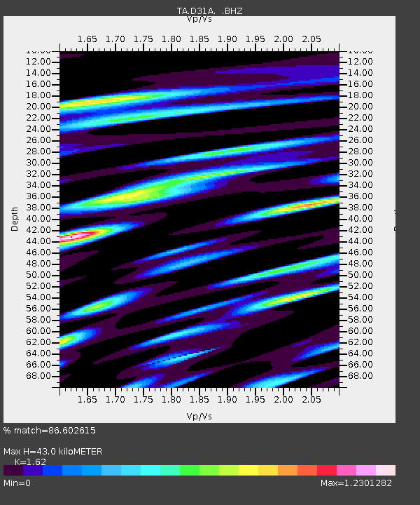
D31A Mcclaflin, Tower City, ND, USA - Earthquake Result Viewer
| Earthquake location: |
Near East Coast Of Honshu, Japan |
| Earthquake latitude/longitude: |
40.3/142.8 |
| Earthquake time(UTC): |
2011/09/16 (259) 19:26:40 GMT |
| Earthquake Depth: |
35 km |
| Earthquake Magnitude: |
6.0 MB, 6.5 MS, 6.7 MW, 6.7 MW |
| Earthquake Catalog/Contributor: |
WHDF/NEIC |
|
| Network: |
TA USArray Transportable Network (new EarthScope stations) |
| Station: |
D31A Mcclaflin, Tower City, ND, USA |
| Lat/Lon: |
47.05 N/97.72 W |
| Elevation: |
359 m |
|
| Distance: |
77.8 deg |
| Az: |
37.522 deg |
| Baz: |
317.041 deg |
| Ray Param: |
0.05005922 |
| Estimated Moho Depth: |
43.0 km |
| Estimated Crust Vp/Vs: |
1.62 |
| Assumed Crust Vp: |
6.498 km/s |
| Estimated Crust Vs: |
4.011 km/s |
| Estimated Crust Poisson's Ratio: |
0.19 |
|
| Radial Match: |
86.602615 % |
| Radial Bump: |
400 |
| Transverse Match: |
72.400764 % |
| Transverse Bump: |
400 |
| SOD ConfigId: |
414626 |
| Insert Time: |
2012-01-23 13:58:23.396 +0000 |
| GWidth: |
2.5 |
| Max Bumps: |
400 |
| Tol: |
0.001 |
|

Signal To Noise
| Channel | StoN | STA | LTA |
| TA:D31A: :BHZ:20110916T19:38:03.375029Z | 1.736237 | 6.0779433E-7 | 3.5006417E-7 |
| TA:D31A: :BHN:20110916T19:38:03.375029Z | 1.4219043 | 4.2808028E-7 | 3.0106122E-7 |
| TA:D31A: :BHE:20110916T19:38:03.375029Z | 1.0368546 | 2.9240397E-7 | 2.820106E-7 |
| Arrivals |
| Ps | 4.2 SECOND |
| PpPs | 17 SECOND |
| PsPs/PpSs | 21 SECOND |


