You are here: Home > Network List > IU - Global Seismograph Network (GSN - IRIS/USGS) Stations List
> Station RSSD Black Hills, South Dakota, USA > Earthquake Result Viewer
RSSD Black Hills, South Dakota, USA - Earthquake Result Viewer
*The percent match for this event was below the threshold and hence no stack was calculated.
| Earthquake location: |
Laptev Sea |
| Earthquake latitude/longitude: |
74.9/133.8 |
| Earthquake time(UTC): |
2014/04/11 (101) 13:27:05 GMT |
| Earthquake Depth: |
10 km |
| Earthquake Magnitude: |
4.2 mb |
| Earthquake Catalog/Contributor: |
ISC/ISC |
|
| Network: |
IU Global Seismograph Network (GSN - IRIS/USGS) |
| Station: |
RSSD Black Hills, South Dakota, USA |
| Lat/Lon: |
44.12 N/104.04 W |
| Elevation: |
2090 m |
|
| Distance: |
55.4 deg |
| Az: |
47.828 deg |
| Baz: |
344.301 deg |
| Ray Param: |
$rayparam |
*The percent match for this event was below the threshold and hence was not used in the summary stack. |
|
| Radial Match: |
49.580273 % |
| Radial Bump: |
222 |
| Transverse Match: |
61.008945 % |
| Transverse Bump: |
400 |
| SOD ConfigId: |
3390531 |
| Insert Time: |
2019-04-11 07:19:33.304 +0000 |
| GWidth: |
2.5 |
| Max Bumps: |
400 |
| Tol: |
0.001 |
|
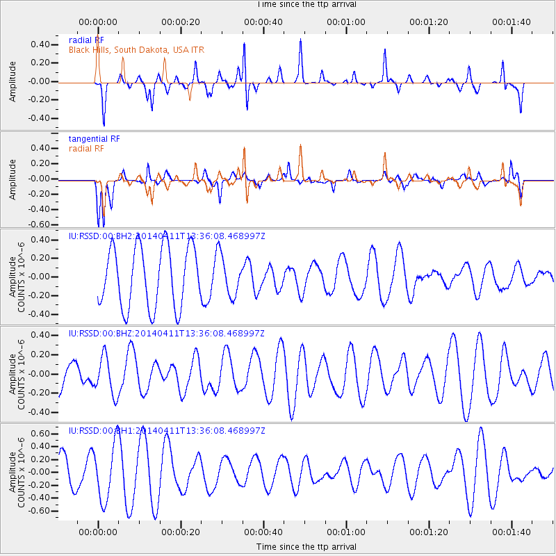
Signal To Noise
| Channel | StoN | STA | LTA |
| IU:RSSD:00:BHZ:20140411T13:36:08.468997Z | 0.69001 | 2.032617E-7 | 2.945779E-7 |
| IU:RSSD:00:BH1:20140411T13:36:08.468997Z | 1.6412259 | 4.477834E-7 | 2.728347E-7 |
| IU:RSSD:00:BH2:20140411T13:36:08.468997Z | 0.6556683 | 2.1300832E-7 | 3.2487205E-7 |
| Arrivals |
| Ps | |
| PpPs | |
| PsPs/PpSs | |


