You are here: Home > Network List > TA - USArray Transportable Network (new EarthScope stations) Stations List
> Station F33A 5 Mile Ranch, Herman, MN, USA > Earthquake Result Viewer
F33A 5 Mile Ranch, Herman, MN, USA - Earthquake Result Viewer
| Earthquake location: |
Near East Coast Of Honshu, Japan |
| Earthquake latitude/longitude: |
40.3/142.8 |
| Earthquake time(UTC): |
2011/09/16 (259) 19:26:40 GMT |
| Earthquake Depth: |
35 km |
| Earthquake Magnitude: |
6.0 MB, 6.5 MS, 6.7 MW, 6.7 MW |
| Earthquake Catalog/Contributor: |
WHDF/NEIC |
|
| Network: |
TA USArray Transportable Network (new EarthScope stations) |
| Station: |
F33A 5 Mile Ranch, Herman, MN, USA |
| Lat/Lon: |
45.84 N/96.29 W |
| Elevation: |
313 m |
|
| Distance: |
79.3 deg |
| Az: |
37.609 deg |
| Baz: |
318.092 deg |
| Ray Param: |
0.048999134 |
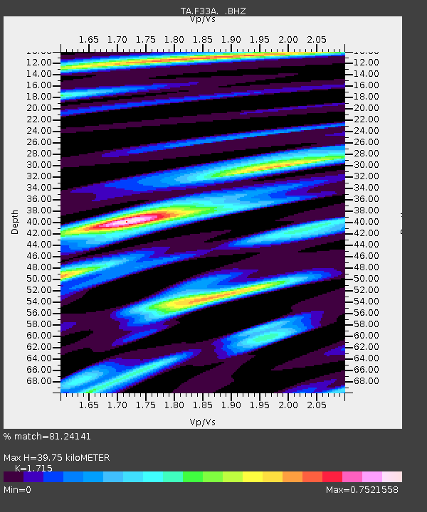
| Estimated Moho Depth: |
39.75 km |
| Estimated Crust Vp/Vs: |
1.72 |
| Assumed Crust Vp: |
6.552 km/s |
| Estimated Crust Vs: |
3.821 km/s |
| Estimated Crust Poisson's Ratio: |
0.24 |
|
| Radial Match: |
81.24141 % |
| Radial Bump: |
400 |
| Transverse Match: |
57.128532 % |
| Transverse Bump: |
400 |
| SOD ConfigId: |
414626 |
| Insert Time: |
2012-01-23 13:58:52.278 +0000 |
| GWidth: |
2.5 |
| Max Bumps: |
400 |
| Tol: |
0.001 |
|

Signal To Noise
| Channel | StoN | STA | LTA |
| TA:F33A: :BHZ:20110916T19:38:11.925017Z | 2.507731 | 4.974379E-7 | 1.9836173E-7 |
| TA:F33A: :BHN:20110916T19:38:11.925017Z | 0.8202164 | 3.1019354E-7 | 3.78185E-7 |
| TA:F33A: :BHE:20110916T19:38:11.925017Z | 1.8743469 | 2.7199596E-7 | 1.4511507E-7 |
| Arrivals |
| Ps | 4.5 SECOND |
| PpPs | 16 SECOND |
| PsPs/PpSs | 20 SECOND |


