You are here: Home > Network List > TA - USArray Transportable Network (new EarthScope stations) Stations List
> Station D36A Goodland, MN, USA > Earthquake Result Viewer
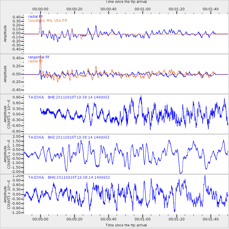
D36A Goodland, MN, USA - Earthquake Result Viewer
*The percent match for this event was below the threshold and hence no stack was calculated.
| Earthquake location: |
Near East Coast Of Honshu, Japan |
| Earthquake latitude/longitude: |
40.3/142.8 |
| Earthquake time(UTC): |
2011/09/16 (259) 19:26:40 GMT |
| Earthquake Depth: |
35 km |
| Earthquake Magnitude: |
6.0 MB, 6.5 MS, 6.7 MW, 6.7 MW |
| Earthquake Catalog/Contributor: |
WHDF/NEIC |
|
| Network: |
TA USArray Transportable Network (new EarthScope stations) |
| Station: |
D36A Goodland, MN, USA |
| Lat/Lon: |
47.18 N/93.16 W |
| Elevation: |
434 m |
|
| Distance: |
79.7 deg |
| Az: |
35.059 deg |
| Baz: |
319.89 deg |
| Ray Param: |
$rayparam |
*The percent match for this event was below the threshold and hence was not used in the summary stack. |
|
| Radial Match: |
79.61086 % |
| Radial Bump: |
400 |
| Transverse Match: |
56.98115 % |
| Transverse Bump: |
400 |
| SOD ConfigId: |
414626 |
| Insert Time: |
2012-01-23 13:59:22.407 +0000 |
| GWidth: |
2.5 |
| Max Bumps: |
400 |
| Tol: |
0.001 |
|
Signal To Noise
| Channel | StoN | STA | LTA |
| TA:D36A: :BHZ:20110916T19:38:14.149993Z | 3.6089373 | 5.2450207E-7 | 1.4533423E-7 |
| TA:D36A: :BHN:20110916T19:38:14.149993Z | 0.75228494 | 1.9374049E-7 | 2.5753604E-7 |
| TA:D36A: :BHE:20110916T19:38:14.149993Z | 2.3344028 | 3.5685204E-7 | 1.5286653E-7 |
| Arrivals |
| Ps | |
| PpPs | |
| PsPs/PpSs | |


