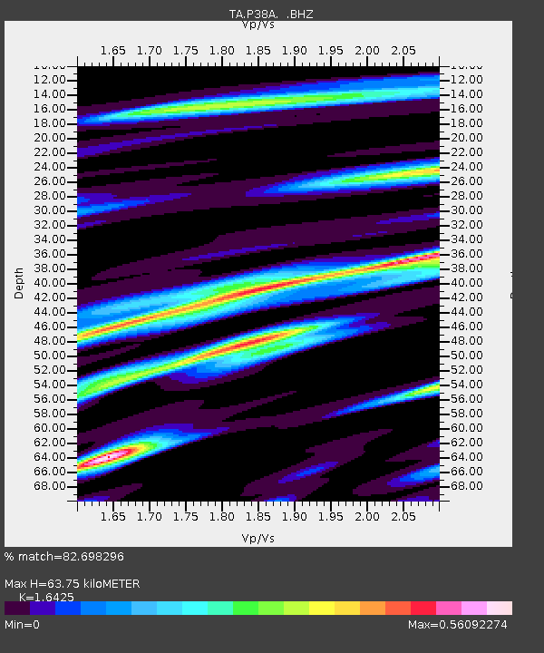
P38A Dawn, MO, USA - Earthquake Result Viewer

Earthquake location: Near East Coast Of Honshu, Japan
Earthquake latitude/longitude: 40.3/142.8
Earthquake time(UTC): 2011/09/16 (259) 19:26:40 GMT
Earthquake Depth: 35 km
Earthquake Magnitude: 6.0 MB, 6.5 MS, 6.7 MW, 6.7 MW
Earthquake Catalog/Contributor: WHDF/NEIC
Network: TA USArray Transportable Network (new EarthScope stations)
Station: P38A Dawn, MO, USA
Lat/Lon: 39.62 N/93.53 W
Elevation: 248 m
Distance: 85.3 deg
Az: 40.148 deg
Baz: 320.301 deg
Ray Param: 0.044786584
Estimated Moho Depth: 63.75 km
Estimated Crust Vp/Vs: 1.64
Assumed Crust Vp: 6.498 km/s
Estimated Crust Vs: 3.956 km/s
Estimated Crust Poisson's Ratio: 0.21
Radial Match: 82.698296 %
Radial Bump: 328
Transverse Match: 77.96584 %
Transverse Bump: 400
SOD ConfigId: 414626
Insert Time: 2012-01-23 14:01:37.258 +0000
GWidth: 2.5
Max Bumps: 400
Tol: 0.001

Signal To Noise

ChannelStoNSTALTA
TA:P38A: :BHZ:20110916T19:38:43.300017Z3.825945.8755404E-71.5357116E-7
TA:P38A: :BHN:20110916T19:38:43.300017Z1.29559152.414948E-71.8639734E-7
TA:P38A: :BHE:20110916T19:38:43.300017Z0.963747261.768885E-71.8354243E-7
Arrivals
Ps6.5 SECOND
PpPs25 SECOND
PsPs/PpSs32 SECOND