You are here: Home > Network List > BK - Berkeley Digital Seismograph Network Stations List
> Station HUMO Hull Mountain, OR > Earthquake Result Viewer
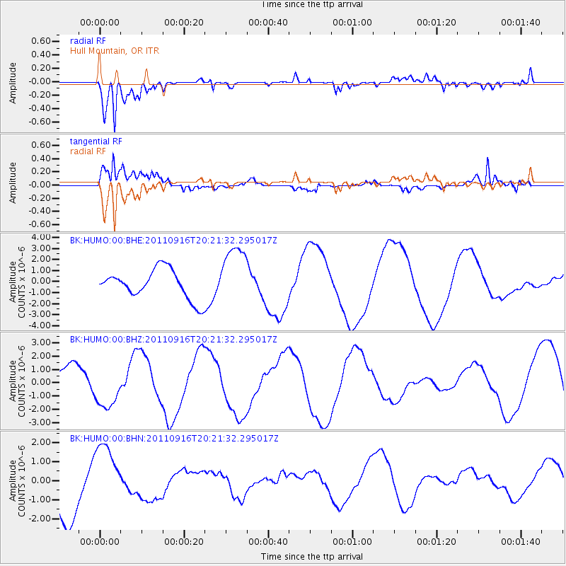
HUMO Hull Mountain, OR - Earthquake Result Viewer
*The percent match for this event was below the threshold and hence no stack was calculated.
| Earthquake location: |
Off East Coast Of Honshu, Japan |
| Earthquake latitude/longitude: |
40.2/143.2 |
| Earthquake time(UTC): |
2011/09/16 (259) 20:11:16 GMT |
| Earthquake Depth: |
35 km |
| Earthquake Magnitude: |
5.5 MB, 5.8 MW |
| Earthquake Catalog/Contributor: |
WHDF/NEIC |
|
| Network: |
BK Berkeley Digital Seismograph Network |
| Station: |
HUMO Hull Mountain, OR |
| Lat/Lon: |
42.61 N/122.96 W |
| Elevation: |
555 m |
|
| Distance: |
66.6 deg |
| Az: |
53.361 deg |
| Baz: |
303.691 deg |
| Ray Param: |
$rayparam |
*The percent match for this event was below the threshold and hence was not used in the summary stack. |
|
| Radial Match: |
84.62376 % |
| Radial Bump: |
400 |
| Transverse Match: |
50.52945 % |
| Transverse Bump: |
400 |
| SOD ConfigId: |
414626 |
| Insert Time: |
2012-01-23 14:15:46.978 +0000 |
| GWidth: |
2.5 |
| Max Bumps: |
400 |
| Tol: |
0.001 |
|
Signal To Noise
| Channel | StoN | STA | LTA |
| BK:HUMO:00:BHZ:20110916T20:21:32.295017Z | 1.3036593 | 1.6019529E-6 | 1.2288125E-6 |
| BK:HUMO:00:BHN:20110916T20:21:32.295017Z | 1.2473456 | 1.7826048E-6 | 1.4291187E-6 |
| BK:HUMO:00:BHE:20110916T20:21:32.295017Z | 2.1655943 | 2.833493E-6 | 1.3084136E-6 |
| Arrivals |
| Ps | |
| PpPs | |
| PsPs/PpSs | |


