You are here: Home > Network List > TA - USArray Transportable Network (new EarthScope stations) Stations List
> Station 536A Bastrop, TX, USA > Earthquake Result Viewer
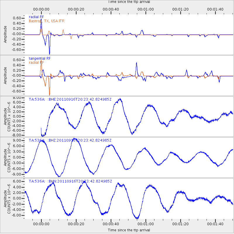
536A Bastrop, TX, USA - Earthquake Result Viewer
*The percent match for this event was below the threshold and hence no stack was calculated.
| Earthquake location: |
Off East Coast Of Honshu, Japan |
| Earthquake latitude/longitude: |
40.2/143.2 |
| Earthquake time(UTC): |
2011/09/16 (259) 20:11:16 GMT |
| Earthquake Depth: |
35 km |
| Earthquake Magnitude: |
5.5 MB, 5.8 MW |
| Earthquake Catalog/Contributor: |
WHDF/NEIC |
|
| Network: |
TA USArray Transportable Network (new EarthScope stations) |
| Station: |
536A Bastrop, TX, USA |
| Lat/Lon: |
30.08 N/97.07 W |
| Elevation: |
115 m |
|
| Distance: |
90.5 deg |
| Az: |
48.852 deg |
| Baz: |
318.316 deg |
| Ray Param: |
$rayparam |
*The percent match for this event was below the threshold and hence was not used in the summary stack. |
|
| Radial Match: |
91.99452 % |
| Radial Bump: |
334 |
| Transverse Match: |
70.37751 % |
| Transverse Bump: |
400 |
| SOD ConfigId: |
414626 |
| Insert Time: |
2012-01-23 14:23:50.839 +0000 |
| GWidth: |
2.5 |
| Max Bumps: |
400 |
| Tol: |
0.001 |
|
Signal To Noise
| Channel | StoN | STA | LTA |
| TA:536A: :BHZ:20110916T20:23:42.824985Z | 1.799741 | 8.381217E-6 | 4.656902E-6 |
| TA:536A: :BHN:20110916T20:23:42.824985Z | 1.4112774 | 3.1373095E-6 | 2.223028E-6 |
| TA:536A: :BHE:20110916T20:23:42.824985Z | 0.86284477 | 3.5819314E-6 | 4.151305E-6 |
| Arrivals |
| Ps | |
| PpPs | |
| PsPs/PpSs | |


