You are here: Home > Network List > TA - USArray Transportable Network (new EarthScope stations) Stations List
> Station V38A Canehill, AR, USA > Earthquake Result Viewer
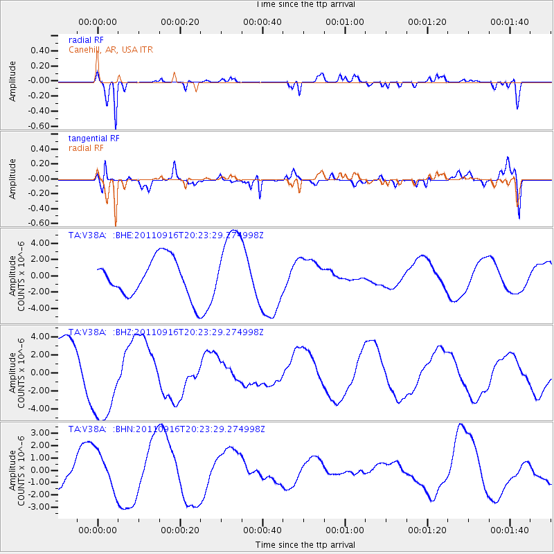
V38A Canehill, AR, USA - Earthquake Result Viewer
*The percent match for this event was below the threshold and hence no stack was calculated.
| Earthquake location: |
Off East Coast Of Honshu, Japan |
| Earthquake latitude/longitude: |
40.2/143.2 |
| Earthquake time(UTC): |
2011/09/16 (259) 20:11:16 GMT |
| Earthquake Depth: |
35 km |
| Earthquake Magnitude: |
5.5 MB, 5.8 MW |
| Earthquake Catalog/Contributor: |
WHDF/NEIC |
|
| Network: |
TA USArray Transportable Network (new EarthScope stations) |
| Station: |
V38A Canehill, AR, USA |
| Lat/Lon: |
35.86 N/94.41 W |
| Elevation: |
372 m |
|
| Distance: |
87.6 deg |
| Az: |
43.379 deg |
| Baz: |
319.662 deg |
| Ray Param: |
$rayparam |
*The percent match for this event was below the threshold and hence was not used in the summary stack. |
|
| Radial Match: |
92.49783 % |
| Radial Bump: |
253 |
| Transverse Match: |
63.17746 % |
| Transverse Bump: |
400 |
| SOD ConfigId: |
414626 |
| Insert Time: |
2012-01-23 14:24:53.092 +0000 |
| GWidth: |
2.5 |
| Max Bumps: |
400 |
| Tol: |
0.001 |
|
Signal To Noise
| Channel | StoN | STA | LTA |
| TA:V38A: :BHZ:20110916T20:23:29.274998Z | 1.9845 | 4.912717E-6 | 2.475544E-6 |
| TA:V38A: :BHN:20110916T20:23:29.274998Z | 1.4570494 | 1.5405004E-6 | 1.0572741E-6 |
| TA:V38A: :BHE:20110916T20:23:29.274998Z | 2.018383 | 4.678046E-6 | 2.3177197E-6 |
| Arrivals |
| Ps | |
| PpPs | |
| PsPs/PpSs | |


