You are here: Home > Network List > TA - USArray Transportable Network (new EarthScope stations) Stations List
> Station J37A Redenius Farm, Forest, IA, USA > Earthquake Result Viewer
J37A Redenius Farm, Forest, IA, USA - Earthquake Result Viewer
| Earthquake location: |
Off East Coast Of Honshu, Japan |
| Earthquake latitude/longitude: |
40.2/143.2 |
| Earthquake time(UTC): |
2011/09/16 (259) 20:11:16 GMT |
| Earthquake Depth: |
35 km |
| Earthquake Magnitude: |
5.5 MB, 5.8 MW |
| Earthquake Catalog/Contributor: |
WHDF/NEIC |
|
| Network: |
TA USArray Transportable Network (new EarthScope stations) |
| Station: |
J37A Redenius Farm, Forest, IA, USA |
| Lat/Lon: |
43.31 N/93.55 W |
| Elevation: |
385 m |
|
| Distance: |
82.3 deg |
| Az: |
38.045 deg |
| Baz: |
319.735 deg |
| Ray Param: |
0.046924572 |
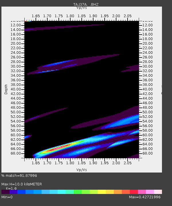
| Estimated Moho Depth: |
10.0 km |
| Estimated Crust Vp/Vs: |
1.60 |
| Assumed Crust Vp: |
6.53 km/s |
| Estimated Crust Vs: |
4.082 km/s |
| Estimated Crust Poisson's Ratio: |
0.18 |
|
| Radial Match: |
91.87996 % |
| Radial Bump: |
372 |
| Transverse Match: |
85.40517 % |
| Transverse Bump: |
346 |
| SOD ConfigId: |
414626 |
| Insert Time: |
2012-01-23 14:26:09.432 +0000 |
| GWidth: |
2.5 |
| Max Bumps: |
400 |
| Tol: |
0.001 |
|
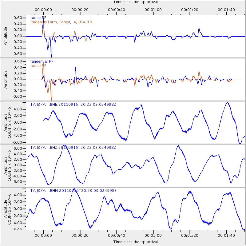
Signal To Noise
| Channel | StoN | STA | LTA |
| TA:J37A: :BHZ:20110916T20:23:03.024998Z | 2.3138394 | 5.6733506E-6 | 2.4519206E-6 |
| TA:J37A: :BHN:20110916T20:23:03.024998Z | 1.2821442 | 2.5418274E-6 | 1.9824815E-6 |
| TA:J37A: :BHE:20110916T20:23:03.024998Z | 0.7109469 | 1.7263259E-6 | 2.4282062E-6 |
| Arrivals |
| Ps | 0.9 SECOND |
| PpPs | 3.9 SECOND |
| PsPs/PpSs | 4.8 SECOND |


