You are here: Home > Network List > TA - USArray Transportable Network (new EarthScope stations) Stations List
> Station M36A Felix, Anita, IA, USA > Earthquake Result Viewer
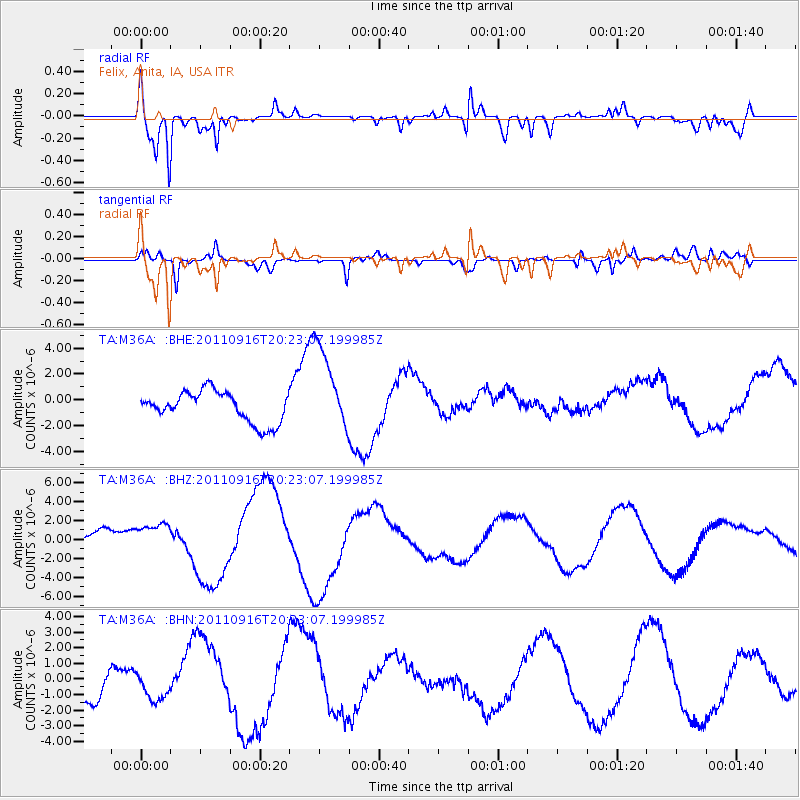
M36A Felix, Anita, IA, USA - Earthquake Result Viewer
*The percent match for this event was below the threshold and hence no stack was calculated.
| Earthquake location: |
Off East Coast Of Honshu, Japan |
| Earthquake latitude/longitude: |
40.2/143.2 |
| Earthquake time(UTC): |
2011/09/16 (259) 20:11:16 GMT |
| Earthquake Depth: |
35 km |
| Earthquake Magnitude: |
5.5 MB, 5.8 MW |
| Earthquake Catalog/Contributor: |
WHDF/NEIC |
|
| Network: |
TA USArray Transportable Network (new EarthScope stations) |
| Station: |
M36A Felix, Anita, IA, USA |
| Lat/Lon: |
41.45 N/94.80 W |
| Elevation: |
430 m |
|
| Distance: |
83.1 deg |
| Az: |
39.97 deg |
| Baz: |
319.14 deg |
| Ray Param: |
$rayparam |
*The percent match for this event was below the threshold and hence was not used in the summary stack. |
|
| Radial Match: |
86.778564 % |
| Radial Bump: |
400 |
| Transverse Match: |
60.458237 % |
| Transverse Bump: |
383 |
| SOD ConfigId: |
414626 |
| Insert Time: |
2012-01-23 14:26:28.526 +0000 |
| GWidth: |
2.5 |
| Max Bumps: |
400 |
| Tol: |
0.001 |
|
Signal To Noise
| Channel | StoN | STA | LTA |
| TA:M36A: :BHZ:20110916T20:23:07.199985Z | 0.6133113 | 1.57525E-6 | 2.5684346E-6 |
| TA:M36A: :BHN:20110916T20:23:07.199985Z | 0.40722424 | 7.9355027E-7 | 1.9486813E-6 |
| TA:M36A: :BHE:20110916T20:23:07.199985Z | 2.8236141 | 3.3522101E-6 | 1.1872055E-6 |
| Arrivals |
| Ps | |
| PpPs | |
| PsPs/PpSs | |


