You are here: Home > Network List > TA - USArray Transportable Network (new EarthScope stations) Stations List
> Station R40A Maddie's Station, St. Elizabeth, MO, USA > Earthquake Result Viewer
R40A Maddie's Station, St. Elizabeth, MO, USA - Earthquake Result Viewer
| Earthquake location: |
Off East Coast Of Honshu, Japan |
| Earthquake latitude/longitude: |
40.2/143.2 |
| Earthquake time(UTC): |
2011/09/16 (259) 20:11:16 GMT |
| Earthquake Depth: |
35 km |
| Earthquake Magnitude: |
5.5 MB, 5.8 MW |
| Earthquake Catalog/Contributor: |
WHDF/NEIC |
|
| Network: |
TA USArray Transportable Network (new EarthScope stations) |
| Station: |
R40A Maddie's Station, St. Elizabeth, MO, USA |
| Lat/Lon: |
38.29 N/92.27 W |
| Elevation: |
213 m |
|
| Distance: |
86.8 deg |
| Az: |
40.51 deg |
| Baz: |
320.806 deg |
| Ray Param: |
0.043744378 |
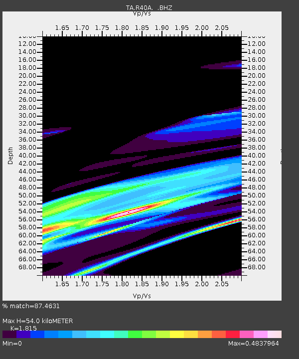
| Estimated Moho Depth: |
54.0 km |
| Estimated Crust Vp/Vs: |
1.82 |
| Assumed Crust Vp: |
6.498 km/s |
| Estimated Crust Vs: |
3.58 km/s |
| Estimated Crust Poisson's Ratio: |
0.28 |
|
| Radial Match: |
87.4631 % |
| Radial Bump: |
383 |
| Transverse Match: |
81.18995 % |
| Transverse Bump: |
355 |
| SOD ConfigId: |
414626 |
| Insert Time: |
2012-01-23 14:26:55.422 +0000 |
| GWidth: |
2.5 |
| Max Bumps: |
400 |
| Tol: |
0.001 |
|

Signal To Noise
| Channel | StoN | STA | LTA |
| TA:R40A: :BHZ:20110916T20:23:25.550022Z | 1.3415331 | 4.4645144E-6 | 3.3279198E-6 |
| TA:R40A: :BHN:20110916T20:23:25.550022Z | 1.3727303 | 2.0139582E-6 | 1.4671188E-6 |
| TA:R40A: :BHE:20110916T20:23:25.550022Z | 0.53148955 | 1.9908819E-6 | 3.7458535E-6 |
| Arrivals |
| Ps | 6.9 SECOND |
| PpPs | 23 SECOND |
| PsPs/PpSs | 30 SECOND |


