You are here: Home > Network List > TA - USArray Transportable Network (new EarthScope stations) Stations List
> Station V39A Pettigrew, AR, USA > Earthquake Result Viewer
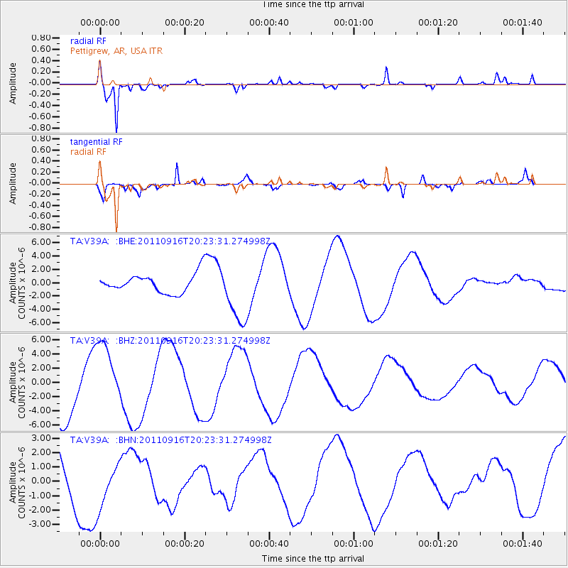
V39A Pettigrew, AR, USA - Earthquake Result Viewer
*The percent match for this event was below the threshold and hence no stack was calculated.
| Earthquake location: |
Off East Coast Of Honshu, Japan |
| Earthquake latitude/longitude: |
40.2/143.2 |
| Earthquake time(UTC): |
2011/09/16 (259) 20:11:16 GMT |
| Earthquake Depth: |
35 km |
| Earthquake Magnitude: |
5.5 MB, 5.8 MW |
| Earthquake Catalog/Contributor: |
WHDF/NEIC |
|
| Network: |
TA USArray Transportable Network (new EarthScope stations) |
| Station: |
V39A Pettigrew, AR, USA |
| Lat/Lon: |
35.84 N/93.64 W |
| Elevation: |
744 m |
|
| Distance: |
88.0 deg |
| Az: |
42.92 deg |
| Baz: |
320.089 deg |
| Ray Param: |
$rayparam |
*The percent match for this event was below the threshold and hence was not used in the summary stack. |
|
| Radial Match: |
92.01253 % |
| Radial Bump: |
359 |
| Transverse Match: |
77.583244 % |
| Transverse Bump: |
374 |
| SOD ConfigId: |
414626 |
| Insert Time: |
2012-01-23 14:27:19.192 +0000 |
| GWidth: |
2.5 |
| Max Bumps: |
400 |
| Tol: |
0.001 |
|
Signal To Noise
| Channel | StoN | STA | LTA |
| TA:V39A: :BHZ:20110916T20:23:31.274998Z | 1.1743339 | 5.0025055E-6 | 4.2598663E-6 |
| TA:V39A: :BHN:20110916T20:23:31.274998Z | 0.48295647 | 1.5167943E-6 | 3.140644E-6 |
| TA:V39A: :BHE:20110916T20:23:31.274998Z | 3.163717 | 4.5401225E-6 | 1.4350596E-6 |
| Arrivals |
| Ps | |
| PpPs | |
| PsPs/PpSs | |


