You are here: Home > Network List > TA - USArray Transportable Network (new EarthScope stations) Stations List
> Station V40A Witts Springs, AR, USA > Earthquake Result Viewer
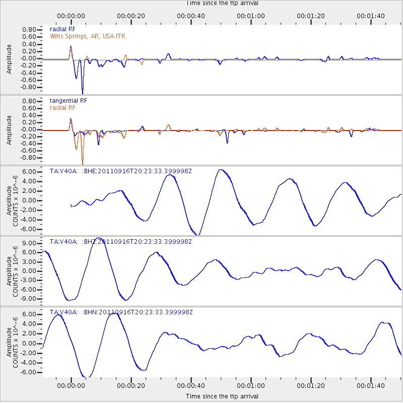
V40A Witts Springs, AR, USA - Earthquake Result Viewer
*The percent match for this event was below the threshold and hence no stack was calculated.
| Earthquake location: |
Off East Coast Of Honshu, Japan |
| Earthquake latitude/longitude: |
40.2/143.2 |
| Earthquake time(UTC): |
2011/09/16 (259) 20:11:16 GMT |
| Earthquake Depth: |
35 km |
| Earthquake Magnitude: |
5.5 MB, 5.8 MW |
| Earthquake Catalog/Contributor: |
WHDF/NEIC |
|
| Network: |
TA USArray Transportable Network (new EarthScope stations) |
| Station: |
V40A Witts Springs, AR, USA |
| Lat/Lon: |
35.80 N/92.82 W |
| Elevation: |
570 m |
|
| Distance: |
88.4 deg |
| Az: |
42.428 deg |
| Baz: |
320.553 deg |
| Ray Param: |
$rayparam |
*The percent match for this event was below the threshold and hence was not used in the summary stack. |
|
| Radial Match: |
94.65131 % |
| Radial Bump: |
375 |
| Transverse Match: |
89.80229 % |
| Transverse Bump: |
290 |
| SOD ConfigId: |
414626 |
| Insert Time: |
2012-01-23 14:27:42.698 +0000 |
| GWidth: |
2.5 |
| Max Bumps: |
400 |
| Tol: |
0.001 |
|
Signal To Noise
| Channel | StoN | STA | LTA |
| TA:V40A: :BHZ:20110916T20:23:33.399998Z | 2.7231307 | 8.081258E-6 | 2.967635E-6 |
| TA:V40A: :BHN:20110916T20:23:33.399998Z | 1.5819849 | 4.1861244E-6 | 2.6461216E-6 |
| TA:V40A: :BHE:20110916T20:23:33.399998Z | 2.7407236 | 4.6907926E-6 | 1.711516E-6 |
| Arrivals |
| Ps | |
| PpPs | |
| PsPs/PpSs | |


