You are here: Home > Network List > TA - USArray Transportable Network (new EarthScope stations) Stations List
> Station O43A Sugar Creek Farm, Atlanta, IL, USA > Earthquake Result Viewer
O43A Sugar Creek Farm, Atlanta, IL, USA - Earthquake Result Viewer
| Earthquake location: |
Off East Coast Of Honshu, Japan |
| Earthquake latitude/longitude: |
40.2/143.2 |
| Earthquake time(UTC): |
2011/09/16 (259) 20:11:16 GMT |
| Earthquake Depth: |
35 km |
| Earthquake Magnitude: |
5.5 MB, 5.8 MW |
| Earthquake Catalog/Contributor: |
WHDF/NEIC |
|
| Network: |
TA USArray Transportable Network (new EarthScope stations) |
| Station: |
O43A Sugar Creek Farm, Atlanta, IL, USA |
| Lat/Lon: |
40.29 N/89.31 W |
| Elevation: |
224 m |
|
| Distance: |
86.7 deg |
| Az: |
37.471 deg |
| Baz: |
322.497 deg |
| Ray Param: |
0.043846007 |
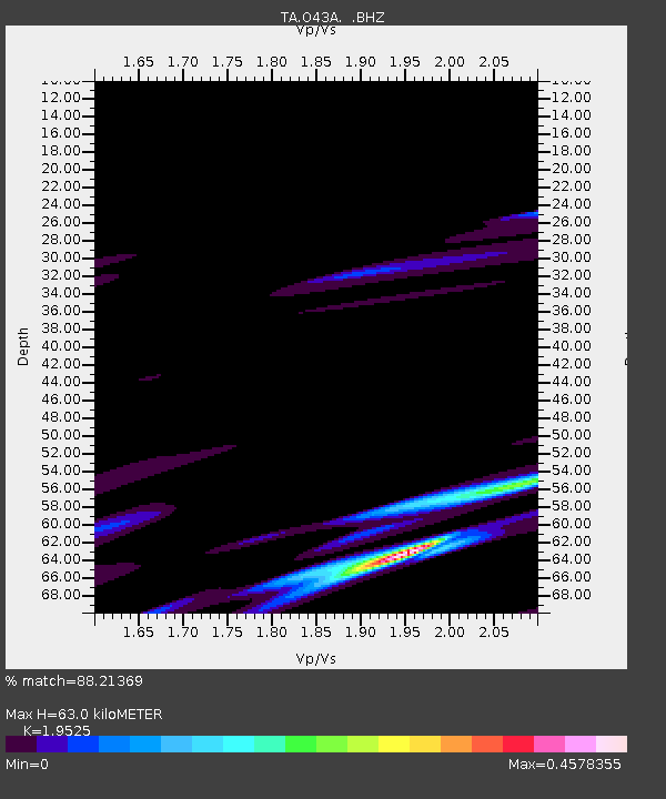
| Estimated Moho Depth: |
63.0 km |
| Estimated Crust Vp/Vs: |
1.95 |
| Assumed Crust Vp: |
6.498 km/s |
| Estimated Crust Vs: |
3.328 km/s |
| Estimated Crust Poisson's Ratio: |
0.32 |
|
| Radial Match: |
88.21369 % |
| Radial Bump: |
400 |
| Transverse Match: |
80.07335 % |
| Transverse Bump: |
349 |
| SOD ConfigId: |
414626 |
| Insert Time: |
2012-01-23 14:29:29.673 +0000 |
| GWidth: |
2.5 |
| Max Bumps: |
400 |
| Tol: |
0.001 |
|
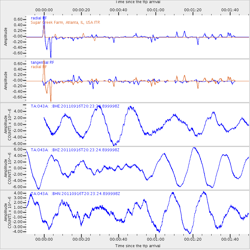
Signal To Noise
| Channel | StoN | STA | LTA |
| TA:O43A: :BHZ:20110916T20:23:24.899998Z | 0.47201073 | 2.4520743E-6 | 5.1949546E-6 |
| TA:O43A: :BHN:20110916T20:23:24.899998Z | 0.8546728 | 2.5424424E-6 | 2.9747553E-6 |
| TA:O43A: :BHE:20110916T20:23:24.899998Z | 2.0062354 | 4.2519096E-6 | 2.1193473E-6 |
| Arrivals |
| Ps | 9.4 SECOND |
| PpPs | 28 SECOND |
| PsPs/PpSs | 37 SECOND |


