You are here: Home > Network List > TA - USArray Transportable Network (new EarthScope stations) Stations List
> Station G41A Antigo, WI, USA > Earthquake Result Viewer
G41A Antigo, WI, USA - Earthquake Result Viewer
| Earthquake location: |
Off East Coast Of Honshu, Japan |
| Earthquake latitude/longitude: |
40.2/143.2 |
| Earthquake time(UTC): |
2011/09/16 (259) 20:11:16 GMT |
| Earthquake Depth: |
35 km |
| Earthquake Magnitude: |
5.5 MB, 5.8 MW |
| Earthquake Catalog/Contributor: |
WHDF/NEIC |
|
| Network: |
TA USArray Transportable Network (new EarthScope stations) |
| Station: |
G41A Antigo, WI, USA |
| Lat/Lon: |
45.21 N/89.18 W |
| Elevation: |
464 m |
|
| Distance: |
82.8 deg |
| Az: |
34.377 deg |
| Baz: |
322.302 deg |
| Ray Param: |
0.046578526 |
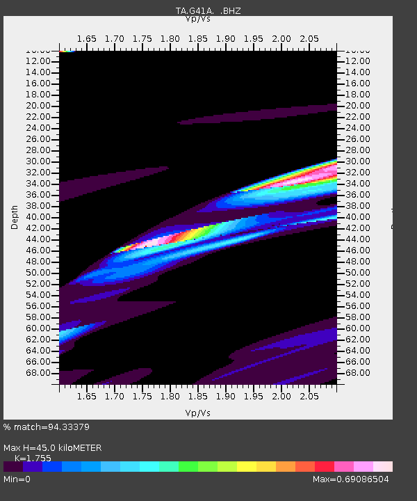
| Estimated Moho Depth: |
45.0 km |
| Estimated Crust Vp/Vs: |
1.75 |
| Assumed Crust Vp: |
6.41 km/s |
| Estimated Crust Vs: |
3.653 km/s |
| Estimated Crust Poisson's Ratio: |
0.26 |
|
| Radial Match: |
94.33379 % |
| Radial Bump: |
332 |
| Transverse Match: |
83.436584 % |
| Transverse Bump: |
392 |
| SOD ConfigId: |
414626 |
| Insert Time: |
2012-01-23 14:29:30.739 +0000 |
| GWidth: |
2.5 |
| Max Bumps: |
400 |
| Tol: |
0.001 |
|
Signal To Noise
| Channel | StoN | STA | LTA |
| TA:G41A: :BHZ:20110916T20:23:05.60001Z | 1.9277344 | 5.456657E-6 | 2.8306063E-6 |
| TA:G41A: :BHN:20110916T20:23:05.60001Z | 2.0508685 | 3.4402838E-6 | 1.6774766E-6 |
| TA:G41A: :BHE:20110916T20:23:05.60001Z | 1.6367537 | 2.8136647E-6 | 1.719052E-6 |
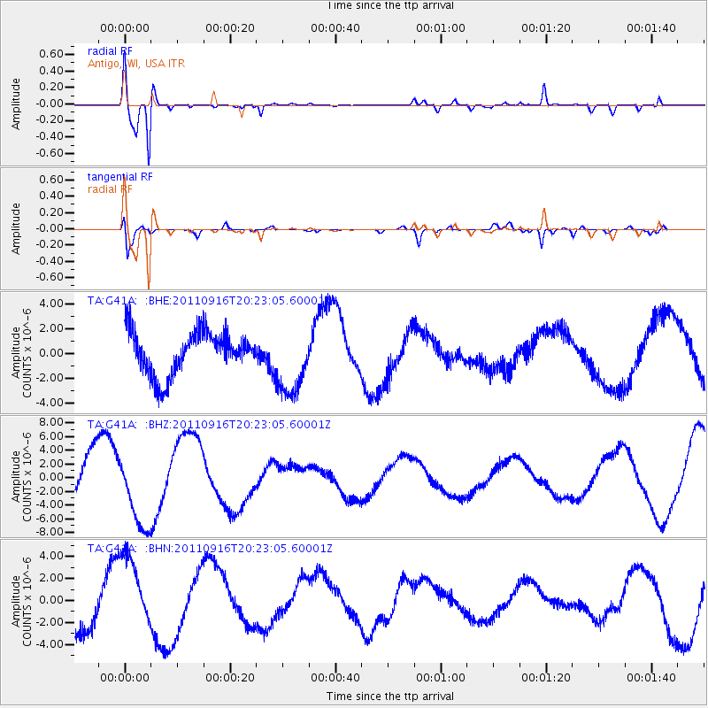
| Arrivals |
| Ps | 5.4 SECOND |
| PpPs | 19 SECOND |
| PsPs/PpSs | 24 SECOND |


