You are here: Home > Network List > CI - Caltech Regional Seismic Network Stations List
> Station LGU Laguna Peak, California, USA > Earthquake Result Viewer
LGU Laguna Peak, California, USA - Earthquake Result Viewer
| Earthquake location: |
Hokkaido, Japan Region |
| Earthquake latitude/longitude: |
42.9/145.2 |
| Earthquake time(UTC): |
2004/12/06 (341) 14:15:11 GMT |
| Earthquake Depth: |
35 km |
| Earthquake Magnitude: |
6.5 MB, 6.5 MS, 6.8 MW, 6.8 MW |
| Earthquake Catalog/Contributor: |
WHDF/NEIC |
|
| Network: |
CI Caltech Regional Seismic Network |
| Station: |
LGU Laguna Peak, California, USA |
| Lat/Lon: |
34.11 N/119.07 W |
| Elevation: |
381 m |
|
| Distance: |
71.5 deg |
| Az: |
60.552 deg |
| Baz: |
309.538 deg |
| Ray Param: |
0.054259453 |
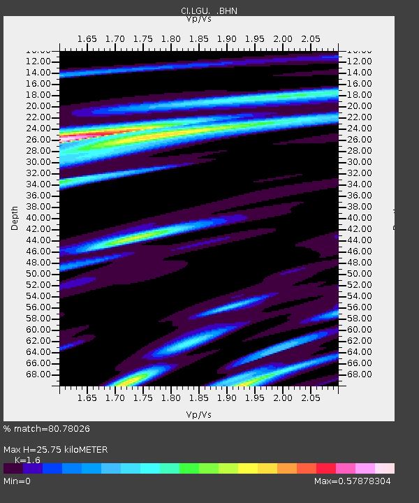
| Estimated Moho Depth: |
25.75 km |
| Estimated Crust Vp/Vs: |
1.60 |
| Assumed Crust Vp: |
6.1 km/s |
| Estimated Crust Vs: |
3.812 km/s |
| Estimated Crust Poisson's Ratio: |
0.18 |
|
| Radial Match: |
80.78026 % |
| Radial Bump: |
400 |
| Transverse Match: |
77.827774 % |
| Transverse Bump: |
364 |
| SOD ConfigId: |
2459 |
| Insert Time: |
2010-02-25 20:18:36.516 +0000 |
| GWidth: |
2.5 |
| Max Bumps: |
400 |
| Tol: |
0.001 |
|
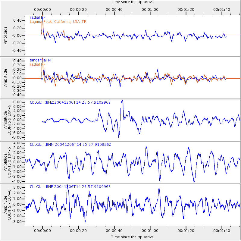
Signal To Noise
| Channel | StoN | STA | LTA |
| CI:LGU: :BHN:20041206T14:25:57.910996Z | 1.0890825 | 8.2542334E-7 | 7.5790706E-7 |
| CI:LGU: :BHE:20041206T14:25:57.910996Z | 1.2029817 | 9.0441534E-7 | 7.518114E-7 |
| CI:LGU: :BHZ:20041206T14:25:57.910996Z | 3.9774446 | 2.3785565E-6 | 5.980112E-7 |
| Arrivals |
| Ps | 2.6 SECOND |
| PpPs | 11 SECOND |
| PsPs/PpSs | 13 SECOND |


