You are here: Home > Network List > X812 - Deep Structure of Three Continental Sutures in Eastern North America Stations List
> Station QM20 Hay Lake, Maine, USA > Earthquake Result Viewer
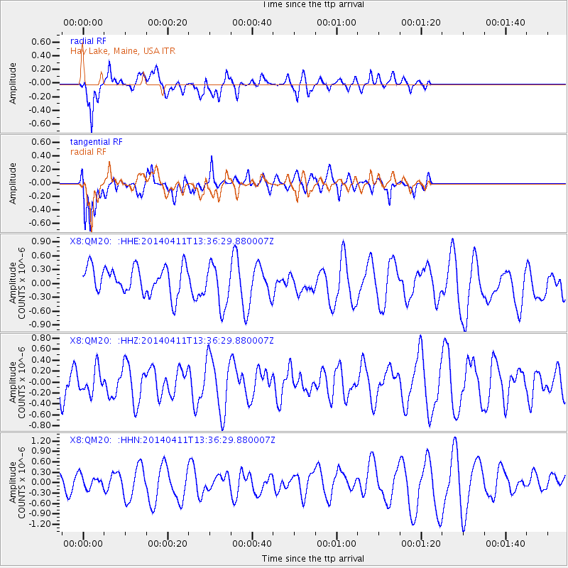
QM20 Hay Lake, Maine, USA - Earthquake Result Viewer
*The percent match for this event was below the threshold and hence no stack was calculated.
| Earthquake location: |
Laptev Sea |
| Earthquake latitude/longitude: |
74.9/133.8 |
| Earthquake time(UTC): |
2014/04/11 (101) 13:27:05 GMT |
| Earthquake Depth: |
10 km |
| Earthquake Magnitude: |
4.2 mb |
| Earthquake Catalog/Contributor: |
ISC/ISC |
|
| Network: |
X8 Deep Structure of Three Continental Sutures in Eastern North America |
| Station: |
QM20 Hay Lake, Maine, USA |
| Lat/Lon: |
46.13 N/68.72 W |
| Elevation: |
207 m |
|
| Distance: |
58.4 deg |
| Az: |
18.231 deg |
| Baz: |
353.207 deg |
| Ray Param: |
$rayparam |
*The percent match for this event was below the threshold and hence was not used in the summary stack. |
|
| Radial Match: |
47.795612 % |
| Radial Bump: |
400 |
| Transverse Match: |
74.711266 % |
| Transverse Bump: |
400 |
| SOD ConfigId: |
3390531 |
| Insert Time: |
2019-04-11 07:24:48.037 +0000 |
| GWidth: |
2.5 |
| Max Bumps: |
400 |
| Tol: |
0.001 |
|
Signal To Noise
| Channel | StoN | STA | LTA |
| X8:QM20: :HHZ:20140411T13:36:29.880007Z | 1.0287306 | 2.2654743E-7 | 2.2022036E-7 |
| X8:QM20: :HHN:20140411T13:36:29.880007Z | 0.7486239 | 1.8403325E-7 | 2.4582872E-7 |
| X8:QM20: :HHE:20140411T13:36:29.880007Z | 1.6234 | 4.7860254E-7 | 2.9481492E-7 |
| Arrivals |
| Ps | |
| PpPs | |
| PsPs/PpSs | |


