You are here: Home > Network List > CI - Caltech Regional Seismic Network Stations List
> Station BEL Belle Mtn, Joshua Tree National Park, CA, USA > Earthquake Result Viewer
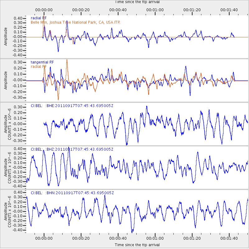
BEL Belle Mtn, Joshua Tree National Park, CA, USA - Earthquake Result Viewer
*The percent match for this event was below the threshold and hence no stack was calculated.
| Earthquake location: |
Near East Coast Of Honshu, Japan |
| Earthquake latitude/longitude: |
40.3/142.7 |
| Earthquake time(UTC): |
2011/09/17 (260) 07:34:27 GMT |
| Earthquake Depth: |
30 km |
| Earthquake Magnitude: |
5.5 MB, 5.2 MS, 5.7 MW, 5.9 ME |
| Earthquake Catalog/Contributor: |
WHDF/NEIC |
|
| Network: |
CI Caltech Regional Seismic Network |
| Station: |
BEL Belle Mtn, Joshua Tree National Park, CA, USA |
| Lat/Lon: |
34.00 N/116.00 W |
| Elevation: |
1388 m |
|
| Distance: |
76.5 deg |
| Az: |
56.893 deg |
| Baz: |
309.508 deg |
| Ray Param: |
$rayparam |
*The percent match for this event was below the threshold and hence was not used in the summary stack. |
|
| Radial Match: |
58.65977 % |
| Radial Bump: |
400 |
| Transverse Match: |
58.66201 % |
| Transverse Bump: |
400 |
| SOD ConfigId: |
414626 |
| Insert Time: |
2012-01-27 13:06:09.759 +0000 |
| GWidth: |
2.5 |
| Max Bumps: |
400 |
| Tol: |
0.001 |
|
Signal To Noise
| Channel | StoN | STA | LTA |
| CI:BEL: :BHZ:20110917T07:45:43.695005Z | 1.7200415 | 2.52037E-7 | 1.4652962E-7 |
| CI:BEL: :BHN:20110917T07:45:43.695005Z | 0.6145981 | 9.20062E-8 | 1.497014E-7 |
| CI:BEL: :BHE:20110917T07:45:43.695005Z | 1.7310505 | 1.3233813E-7 | 7.644961E-8 |
| Arrivals |
| Ps | |
| PpPs | |
| PsPs/PpSs | |


