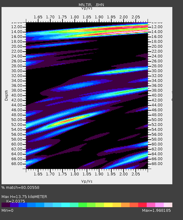
TIR Tirana, Albania - Earthquake Result Viewer
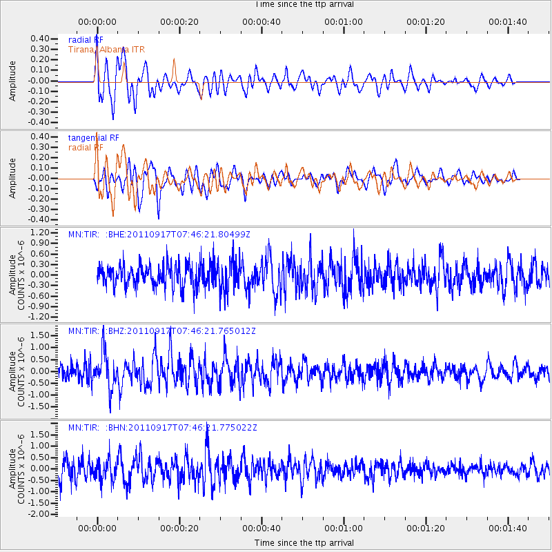
Earthquake location: Near East Coast Of Honshu, Japan
Earthquake latitude/longitude: 40.3/142.7
Earthquake time(UTC): 2011/09/17 (260) 07:34:27 GMT
Earthquake Depth: 30 km
Earthquake Magnitude: 5.5 MB, 5.2 MS, 5.7 MW, 5.9 ME
Earthquake Catalog/Contributor: WHDF/NEIC
Network: MN MEDNET Project
Station: TIR Tirana, Albania
Lat/Lon: 41.35 N/19.86 E
Elevation: 247 m
Distance: 83.6 deg
Az: 320.439 deg
Baz: 40.338 deg
Ray Param: 0.046042167
Estimated Moho Depth: 13.75 km
Estimated Crust Vp/Vs: 2.04
Assumed Crust Vp: 5.967 km/s
Estimated Crust Vs: 2.929 km/s
Estimated Crust Poisson's Ratio: 0.34
Radial Match: 80.00558 %
Radial Bump: 400
Transverse Match: 78.26676 %
Transverse Bump: 400
SOD ConfigId: 414626
Insert Time: 2012-01-27 13:09:32.946 +0000
GWidth: 2.5
Max Bumps: 400
Tol: 0.001

Signal To Noise

ChannelStoNSTALTA
MN:TIR: :BHZ:20110917T07:46:21.765012Z1.9558477.6409196E-73.906706E-7
MN:TIR: :BHN:20110917T07:46:21.775022Z1.15260024.558053E-73.954583E-7
MN:TIR: :BHE:20110917T07:46:21.80499Z1.43335834.2813275E-72.9869207E-7
Arrivals
Ps2.4 SECOND
PpPs6.9 SECOND
PsPs/PpSs9.3 SECOND