You are here: Home > Network List > CI - Caltech Regional Seismic Network Stations List
> Station LGU Laguna Peak, California, USA > Earthquake Result Viewer
LGU Laguna Peak, California, USA - Earthquake Result Viewer

| Earthquake location: |
Hokkaido, Japan Region |
| Earthquake latitude/longitude: |
43.0/145.1 |
| Earthquake time(UTC): |
2004/11/28 (333) 18:32:14 GMT |
| Earthquake Depth: |
39 km |
| Earthquake Magnitude: |
6.4 MB, 6.7 MS, 7.0 MW, 7.0 MW |
| Earthquake Catalog/Contributor: |
WHDF/NEIC |
|
| Network: |
CI Caltech Regional Seismic Network |
| Station: |
LGU Laguna Peak, California, USA |
| Lat/Lon: |
34.11 N/119.07 W |
| Elevation: |
381 m |
|
| Distance: |
71.5 deg |
| Az: |
60.523 deg |
| Baz: |
309.677 deg |
| Ray Param: |
0.054235935 |
| Estimated Moho Depth: |
45.5 km |
| Estimated Crust Vp/Vs: |
1.79 |
| Assumed Crust Vp: |
6.1 km/s |
| Estimated Crust Vs: |
3.403 km/s |
| Estimated Crust Poisson's Ratio: |
0.27 |
|
| Radial Match: |
89.51625 % |
| Radial Bump: |
372 |
| Transverse Match: |
86.93792 % |
| Transverse Bump: |
400 |
| SOD ConfigId: |
2459 |
| Insert Time: |
2010-02-25 20:18:37.356 +0000 |
| GWidth: |
2.5 |
| Max Bumps: |
400 |
| Tol: |
0.001 |
|
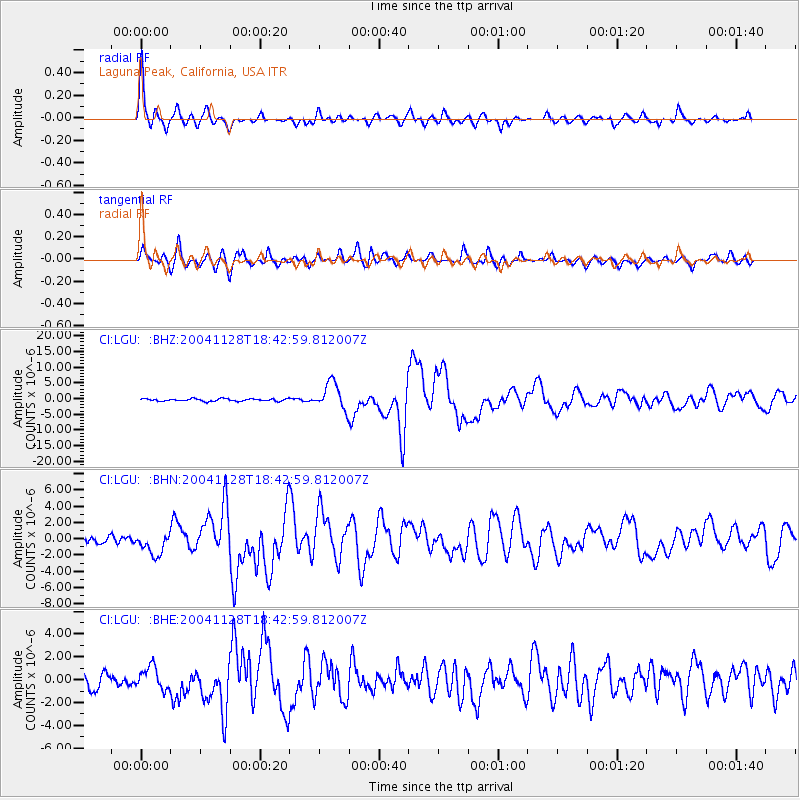
Signal To Noise
| Channel | StoN | STA | LTA |
| CI:LGU: :BHN:20041128T18:42:59.812007Z | 3.0586777 | 1.4376895E-6 | 4.7003633E-7 |
| CI:LGU: :BHE:20041128T18:42:59.812007Z | 1.6692228 | 9.551941E-7 | 5.722388E-7 |
| CI:LGU: :BHZ:20041128T18:42:59.812007Z | 11.205018 | 4.2557435E-6 | 3.7980692E-7 |
| Arrivals |
| Ps | 6.1 SECOND |
| PpPs | 20 SECOND |
| PsPs/PpSs | 26 SECOND |


