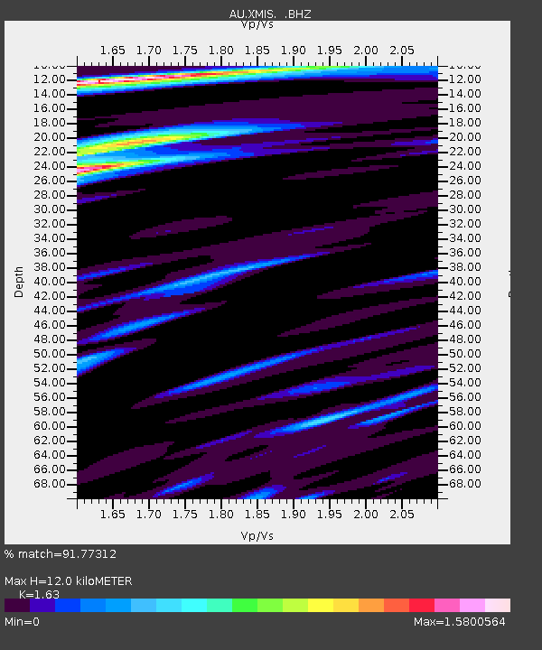
XMIS Christmas Island Grants Well - Earthquake Result Viewer

Earthquake location: Sikkim, India
Earthquake latitude/longitude: 27.7/88.2
Earthquake time(UTC): 2011/09/18 (261) 12:40:51 GMT
Earthquake Depth: 50 km
Earthquake Magnitude: 6.6 MB, 6.7 MS, 6.9 MW, 6.9 MW
Earthquake Catalog/Contributor: WHDF/NEIC
Network: AU Australian Seismological Centre
Station: XMIS Christmas Island Grants Well
Lat/Lon: 10.48 S/105.65 E
Elevation: 210 m
Distance: 41.6 deg
Az: 153.549 deg
Baz: 336.331 deg
Ray Param: 0.07355405
Estimated Moho Depth: 12.0 km
Estimated Crust Vp/Vs: 1.63
Assumed Crust Vp: 4.157 km/s
Estimated Crust Vs: 2.55 km/s
Estimated Crust Poisson's Ratio: 0.20
Radial Match: 91.77312 %
Radial Bump: 400
Transverse Match: 73.5644 %
Transverse Bump: 400
SOD ConfigId: 414626
Insert Time: 2012-01-27 13:22:25.683 +0000
GWidth: 2.5
Max Bumps: 400
Tol: 0.001

Signal To Noise

ChannelStoNSTALTA
AU:XMIS: :BHZ:20110918T12:48:04.44499Z9.192574.292392E-64.6694146E-7
AU:XMIS: :BHN:20110918T12:48:04.44499Z5.84793952.955754E-65.0543514E-7
AU:XMIS: :BHE:20110918T12:48:04.44499Z1.8086731.2441209E-66.878639E-7
Arrivals
Ps1.9 SECOND
PpPs7.4 SECOND
PsPs/PpSs9.2 SECOND