You are here: Home > Network List > G - GEOSCOPE Stations List
> Station TAM Tamanrasset, Algeria > Earthquake Result Viewer
TAM Tamanrasset, Algeria - Earthquake Result Viewer

| Earthquake location: |
Sikkim, India |
| Earthquake latitude/longitude: |
27.7/88.2 |
| Earthquake time(UTC): |
2011/09/18 (261) 12:40:51 GMT |
| Earthquake Depth: |
50 km |
| Earthquake Magnitude: |
6.6 MB, 6.7 MS, 6.9 MW, 6.9 MW |
| Earthquake Catalog/Contributor: |
WHDF/NEIC |
|
| Network: |
G GEOSCOPE |
| Station: |
TAM Tamanrasset, Algeria |
| Lat/Lon: |
22.79 N/5.53 E |
| Elevation: |
1377 m |
|
| Distance: |
73.5 deg |
| Az: |
287.389 deg |
| Baz: |
66.44 deg |
| Ray Param: |
0.05283662 |
| Estimated Moho Depth: |
42.75 km |
| Estimated Crust Vp/Vs: |
1.61 |
| Assumed Crust Vp: |
6.61 km/s |
| Estimated Crust Vs: |
4.112 km/s |
| Estimated Crust Poisson's Ratio: |
0.18 |
|
| Radial Match: |
97.41906 % |
| Radial Bump: |
344 |
| Transverse Match: |
88.38916 % |
| Transverse Bump: |
400 |
| SOD ConfigId: |
414626 |
| Insert Time: |
2012-01-27 13:23:47.043 +0000 |
| GWidth: |
2.5 |
| Max Bumps: |
400 |
| Tol: |
0.001 |
|
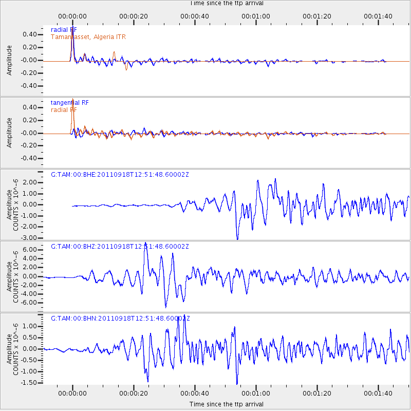
Signal To Noise
| Channel | StoN | STA | LTA |
| G:TAM:00:BHZ:20110918T12:51:48.60002Z | 4.1295595 | 2.38373E-7 | 5.7723586E-8 |
| G:TAM:00:BHN:20110918T12:51:48.60002Z | 1.2839593 | 5.1689167E-8 | 4.025764E-8 |
| G:TAM:00:BHE:20110918T12:51:48.60002Z | 1.5358534 | 7.49193E-8 | 4.878024E-8 |
| Arrivals |
| Ps | 4.1 SECOND |
| PpPs | 16 SECOND |
| PsPs/PpSs | 20 SECOND |


