You are here: Home > Network List > G - GEOSCOPE Stations List
> Station CLF Chambon la Foret observatory, France > Earthquake Result Viewer
CLF Chambon la Foret observatory, France - Earthquake Result Viewer
| Earthquake location: |
Sikkim, India |
| Earthquake latitude/longitude: |
27.7/88.2 |
| Earthquake time(UTC): |
2011/09/18 (261) 12:40:51 GMT |
| Earthquake Depth: |
50 km |
| Earthquake Magnitude: |
6.6 MB, 6.7 MS, 6.9 MW, 6.9 MW |
| Earthquake Catalog/Contributor: |
WHDF/NEIC |
|
| Network: |
G GEOSCOPE |
| Station: |
CLF Chambon la Foret observatory, France |
| Lat/Lon: |
48.03 N/2.26 E |
| Elevation: |
145 m |
|
| Distance: |
67.3 deg |
| Az: |
313.473 deg |
| Baz: |
73.394 deg |
| Ray Param: |
0.056934915 |
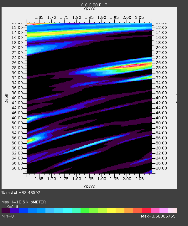
| Estimated Moho Depth: |
10.5 km |
| Estimated Crust Vp/Vs: |
1.60 |
| Assumed Crust Vp: |
6.12 km/s |
| Estimated Crust Vs: |
3.825 km/s |
| Estimated Crust Poisson's Ratio: |
0.18 |
|
| Radial Match: |
83.43592 % |
| Radial Bump: |
400 |
| Transverse Match: |
64.1219 % |
| Transverse Bump: |
400 |
| SOD ConfigId: |
414626 |
| Insert Time: |
2012-01-27 13:23:54.679 +0000 |
| GWidth: |
2.5 |
| Max Bumps: |
400 |
| Tol: |
0.001 |
|
Signal To Noise
| Channel | StoN | STA | LTA |
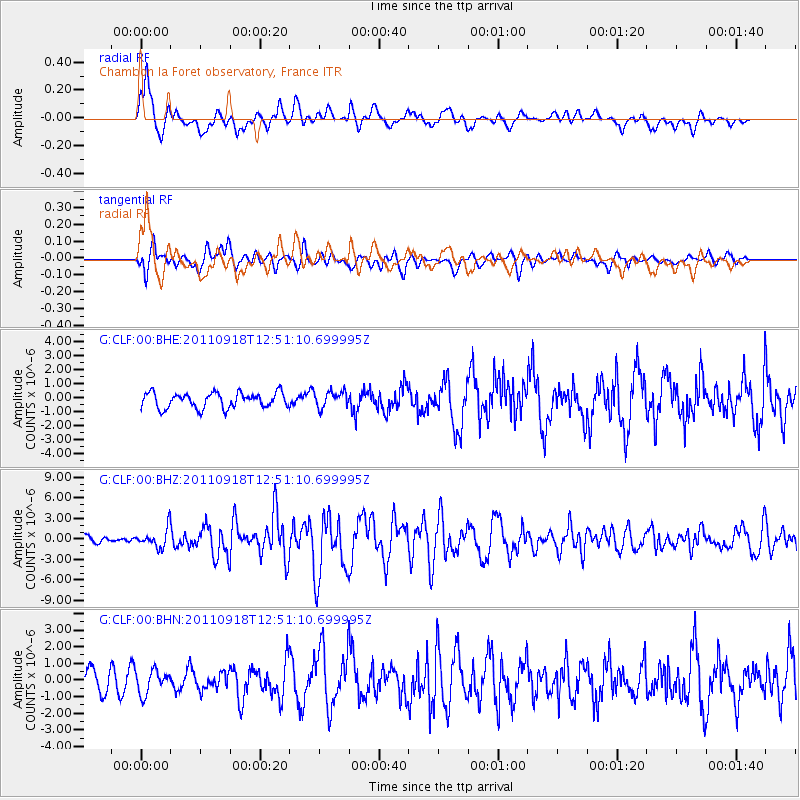
| G:CLF:00:BHZ:20110918T12:51:10.699995Z | 2.1501763 | 1.420975E-6 | 6.6086443E-7 |
| G:CLF:00:BHN:20110918T12:51:10.699995Z | 0.8479113 | 6.958543E-7 | 8.2066873E-7 |
| G:CLF:00:BHE:20110918T12:51:10.699995Z | 1.0992601 | 5.9602223E-7 | 5.422031E-7 |
| Arrivals |
| Ps | 1.1 SECOND |
| PpPs | 4.3 SECOND |
| PsPs/PpSs | 5.4 SECOND |


