You are here: Home > Network List > G - GEOSCOPE Stations List
> Station ATD Arta Cave - Arta, Republic of Djibouti > Earthquake Result Viewer
ATD Arta Cave - Arta, Republic of Djibouti - Earthquake Result Viewer
| Earthquake location: |
Sikkim, India |
| Earthquake latitude/longitude: |
27.7/88.2 |
| Earthquake time(UTC): |
2011/09/18 (261) 12:40:51 GMT |
| Earthquake Depth: |
50 km |
| Earthquake Magnitude: |
6.6 MB, 6.7 MS, 6.9 MW, 6.9 MW |
| Earthquake Catalog/Contributor: |
WHDF/NEIC |
|
| Network: |
G GEOSCOPE |
| Station: |
ATD Arta Cave - Arta, Republic of Djibouti |
| Lat/Lon: |
11.53 N/42.85 E |
| Elevation: |
610 m |
|
| Distance: |
45.3 deg |
| Az: |
258.403 deg |
| Baz: |
62.373 deg |
| Ray Param: |
0.07120714 |
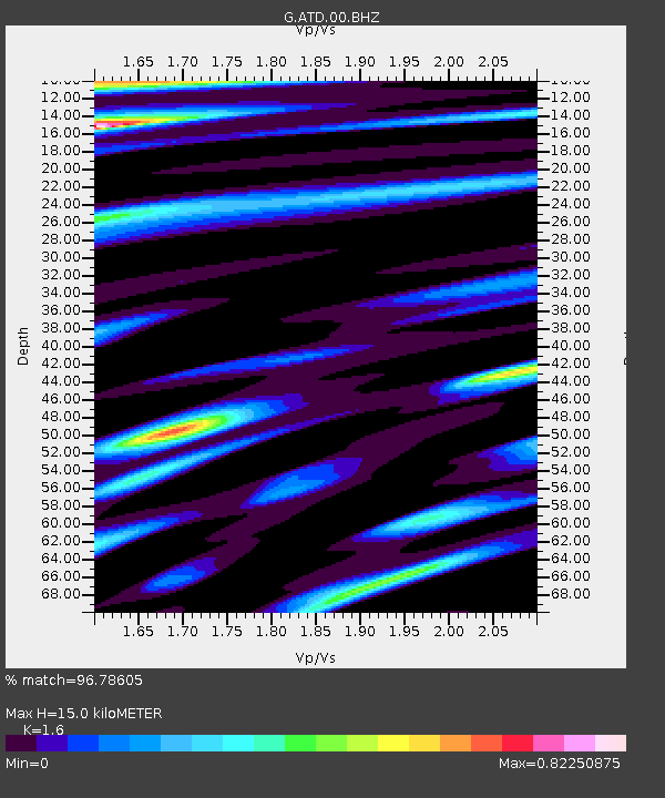
| Estimated Moho Depth: |
15.0 km |
| Estimated Crust Vp/Vs: |
1.60 |
| Assumed Crust Vp: |
6.375 km/s |
| Estimated Crust Vs: |
3.984 km/s |
| Estimated Crust Poisson's Ratio: |
0.18 |
|
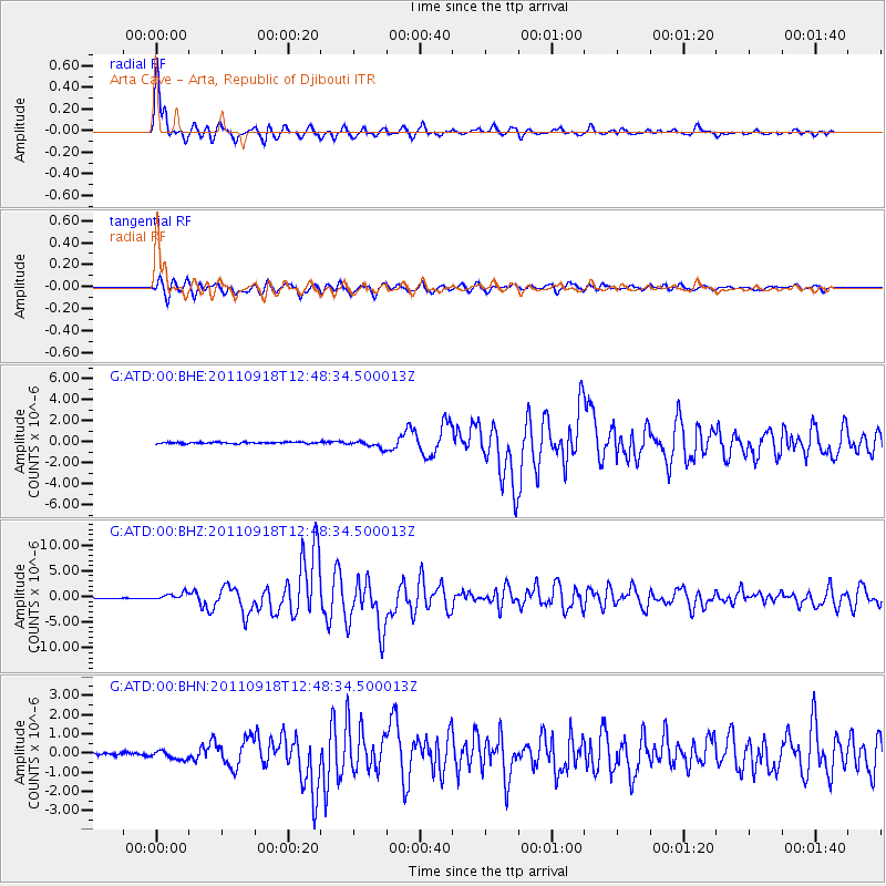
| Radial Match: |
96.78605 % |
| Radial Bump: |
312 |
| Transverse Match: |
90.31297 % |
| Transverse Bump: |
400 |
| SOD ConfigId: |
414626 |
| Insert Time: |
2012-01-27 13:23:59.143 +0000 |
| GWidth: |
2.5 |
| Max Bumps: |
400 |
| Tol: |
0.001 |
|
Signal To Noise
| Channel | StoN | STA | LTA |
| G:ATD:00:BHZ:20110918T12:48:34.500013Z | 7.991921 | 6.742526E-7 | 8.4366775E-8 |
| G:ATD:00:BHN:20110918T12:48:34.500013Z | 2.5845227 | 2.3142586E-7 | 8.954298E-8 |
| G:ATD:00:BHE:20110918T12:48:34.500013Z | 5.0663285 | 3.4882908E-7 | 6.8852444E-8 |
| Arrivals |
| Ps | 1.5 SECOND |
| PpPs | 5.7 SECOND |
| PsPs/PpSs | 7.2 SECOND |


