You are here: Home > Network List > GE - GEOFON Stations List
> Station TIRR GEOFON Station Tirgusor, Romania > Earthquake Result Viewer
TIRR GEOFON Station Tirgusor, Romania - Earthquake Result Viewer
| Earthquake location: |
Sikkim, India |
| Earthquake latitude/longitude: |
27.7/88.2 |
| Earthquake time(UTC): |
2011/09/18 (261) 12:40:51 GMT |
| Earthquake Depth: |
50 km |
| Earthquake Magnitude: |
6.6 MB, 6.7 MS, 6.9 MW, 6.9 MW |
| Earthquake Catalog/Contributor: |
WHDF/NEIC |
|
| Network: |
GE GEOFON |
| Station: |
TIRR GEOFON Station Tirgusor, Romania |
| Lat/Lon: |
44.46 N/28.41 E |
| Elevation: |
77 m |
|
| Distance: |
50.0 deg |
| Az: |
306.139 deg |
| Baz: |
88.527 deg |
| Ray Param: |
0.06822495 |
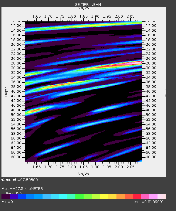
| Estimated Moho Depth: |
27.5 km |
| Estimated Crust Vp/Vs: |
2.10 |
| Assumed Crust Vp: |
6.12 km/s |
| Estimated Crust Vs: |
2.921 km/s |
| Estimated Crust Poisson's Ratio: |
0.35 |
|
| Radial Match: |
97.59589 % |
| Radial Bump: |
363 |
| Transverse Match: |
88.513306 % |
| Transverse Bump: |
400 |
| SOD ConfigId: |
414626 |
| Insert Time: |
2012-01-27 13:24:13.359 +0000 |
| GWidth: |
2.5 |
| Max Bumps: |
400 |
| Tol: |
0.001 |
|

Signal To Noise
| Channel | StoN | STA | LTA |
| GE:TIRR: :BHZ:20110918T12:49:10.520002Z | 7.6753383 | 6.605025E-7 | 8.605517E-8 |
| GE:TIRR: :BHN:20110918T12:49:10.500013Z | 1.3397992 | 9.232785E-8 | 6.891171E-8 |
| GE:TIRR: :BHE:20110918T12:49:10.509993Z | 4.800676 | 4.2697906E-7 | 8.894144E-8 |
| Arrivals |
| Ps | 5.1 SECOND |
| PpPs | 13 SECOND |
| PsPs/PpSs | 18 SECOND |


