You are here: Home > Network List > CI - Caltech Regional Seismic Network Stations List
> Station SWS Sam W. Stewart, Westmorland, CA, USA > Earthquake Result Viewer
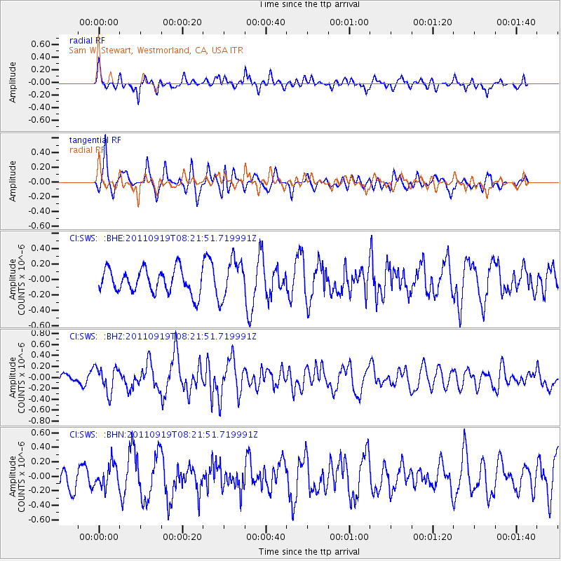
SWS Sam W. Stewart, Westmorland, CA, USA - Earthquake Result Viewer
*The percent match for this event was below the threshold and hence no stack was calculated.
| Earthquake location: |
Fox Islands, Aleutian Islands |
| Earthquake latitude/longitude: |
52.0/-172.0 |
| Earthquake time(UTC): |
2011/09/19 (262) 08:14:14 GMT |
| Earthquake Depth: |
31 km |
| Earthquake Magnitude: |
5.5 MB, 5.1 MS, 5.7 MW, 5.6 MW |
| Earthquake Catalog/Contributor: |
WHDF/NEIC |
|
| Network: |
CI Caltech Regional Seismic Network |
| Station: |
SWS Sam W. Stewart, Westmorland, CA, USA |
| Lat/Lon: |
32.94 N/115.80 W |
| Elevation: |
140 m |
|
| Distance: |
44.4 deg |
| Az: |
92.761 deg |
| Baz: |
312.799 deg |
| Ray Param: |
$rayparam |
*The percent match for this event was below the threshold and hence was not used in the summary stack. |
|
| Radial Match: |
58.30869 % |
| Radial Bump: |
400 |
| Transverse Match: |
50.22189 % |
| Transverse Bump: |
363 |
| SOD ConfigId: |
414626 |
| Insert Time: |
2012-01-27 13:31:52.582 +0000 |
| GWidth: |
2.5 |
| Max Bumps: |
400 |
| Tol: |
0.001 |
|
Signal To Noise
| Channel | StoN | STA | LTA |
| CI:SWS: :BHZ:20110919T08:21:51.719991Z | 3.1108196 | 2.3034451E-7 | 7.404624E-8 |
| CI:SWS: :BHN:20110919T08:21:51.719991Z | 0.83825547 | 1.5684024E-7 | 1.8710315E-7 |
| CI:SWS: :BHE:20110919T08:21:51.719991Z | 1.6151788 | 2.5068792E-7 | 1.5520753E-7 |
| Arrivals |
| Ps | |
| PpPs | |
| PsPs/PpSs | |


